You are here: Home > Network List > UW - Pacific Northwest Regional Seismic Network Stations List
> Station LEBA Lebam, WA, USA > Earthquake Result Viewer
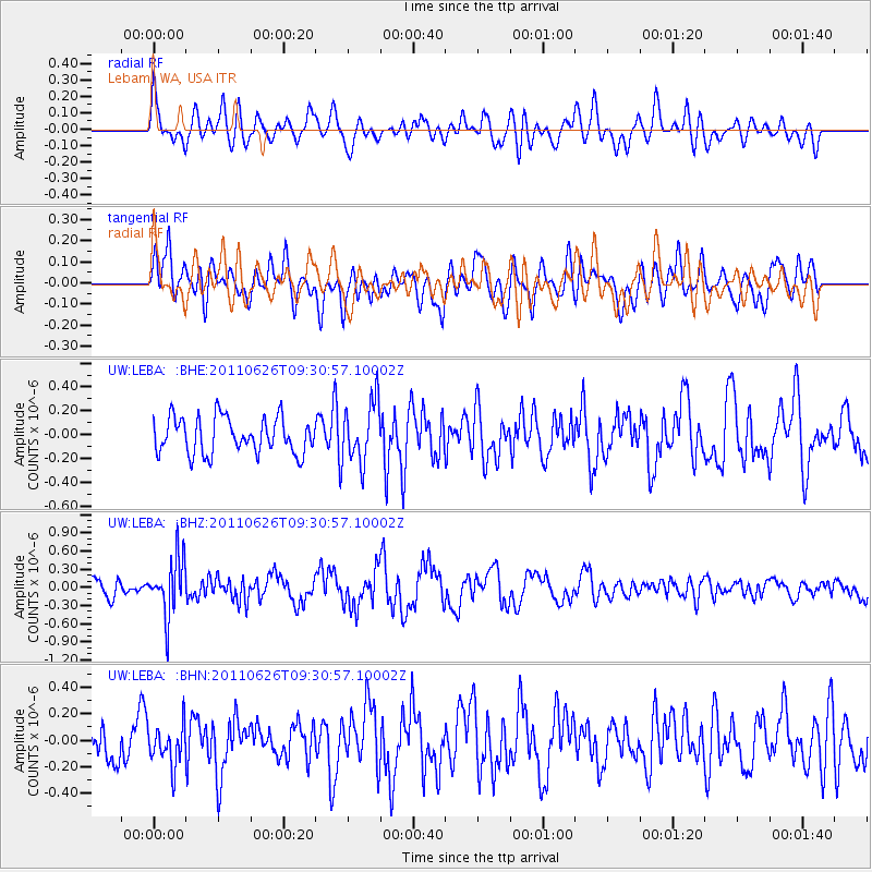
LEBA Lebam, WA, USA - Earthquake Result Viewer
*The percent match for this event was below the threshold and hence no stack was calculated.
| Earthquake location: |
Mariana Islands |
| Earthquake latitude/longitude: |
18.9/146.3 |
| Earthquake time(UTC): |
2011/06/26 (177) 09:19:48 GMT |
| Earthquake Depth: |
99 km |
| Earthquake Magnitude: |
5.6 MB, 5.5 MW, 5.5 MW |
| Earthquake Catalog/Contributor: |
WHDF/NEIC |
|
| Network: |
UW Pacific Northwest Regional Seismic Network |
| Station: |
LEBA Lebam, WA, USA |
| Lat/Lon: |
46.55 N/123.56 W |
| Elevation: |
73 m |
|
| Distance: |
76.7 deg |
| Az: |
45.182 deg |
| Baz: |
283.291 deg |
| Ray Param: |
$rayparam |
*The percent match for this event was below the threshold and hence was not used in the summary stack. |
|
| Radial Match: |
61.657818 % |
| Radial Bump: |
400 |
| Transverse Match: |
50.515705 % |
| Transverse Bump: |
400 |
| SOD ConfigId: |
395004 |
| Insert Time: |
2011-12-08 05:02:26.066 +0000 |
| GWidth: |
2.5 |
| Max Bumps: |
400 |
| Tol: |
0.001 |
|
Signal To Noise
| Channel | StoN | STA | LTA |
| UW:LEBA: :BHZ:20110626T09:30:57.10002Z | 3.5870326 | 4.7389E-7 | 1.3211199E-7 |
| UW:LEBA: :BHN:20110626T09:30:57.10002Z | 0.8074815 | 1.5118817E-7 | 1.8723422E-7 |
| UW:LEBA: :BHE:20110626T09:30:57.10002Z | 1.6767672 | 2.5322498E-7 | 1.5101976E-7 |
| Arrivals |
| Ps | |
| PpPs | |
| PsPs/PpSs | |


