You are here: Home > Network List > G - GEOSCOPE Stations List
> Station ATD Arta Cave, Djibouti > Earthquake Result Viewer
ATD Arta Cave, Djibouti - Earthquake Result Viewer
| Earthquake location: |
Flores Sea |
| Earthquake latitude/longitude: |
-7.1/122.6 |
| Earthquake time(UTC): |
1996/06/17 (169) 11:22:18 GMT |
| Earthquake Depth: |
587 km |
| Earthquake Magnitude: |
6.6 MB, 7.9 UNKNOWN, 7.8 MW |
| Earthquake Catalog/Contributor: |
WHDF/NEIC |
|
| Network: |
G GEOSCOPE |
| Station: |
ATD Arta Cave, Djibouti |
| Lat/Lon: |
11.53 N/42.85 E |
| Elevation: |
610 m |
|
| Distance: |
81.4 deg |
| Az: |
282.772 deg |
| Baz: |
99.08 deg |
| Ray Param: |
0.045796443 |
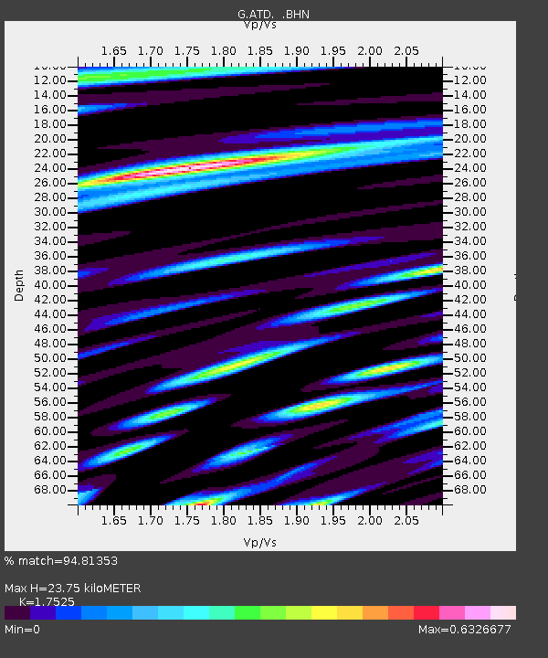
| Estimated Moho Depth: |
23.75 km |
| Estimated Crust Vp/Vs: |
1.75 |
| Assumed Crust Vp: |
6.375 km/s |
| Estimated Crust Vs: |
3.638 km/s |
| Estimated Crust Poisson's Ratio: |
0.26 |
|
| Radial Match: |
94.81353 % |
| Radial Bump: |
400 |
| Transverse Match: |
88.40225 % |
| Transverse Bump: |
400 |
| SOD ConfigId: |
6273 |
| Insert Time: |
2010-02-26 21:28:22.089 +0000 |
| GWidth: |
2.5 |
| Max Bumps: |
400 |
| Tol: |
0.001 |
|
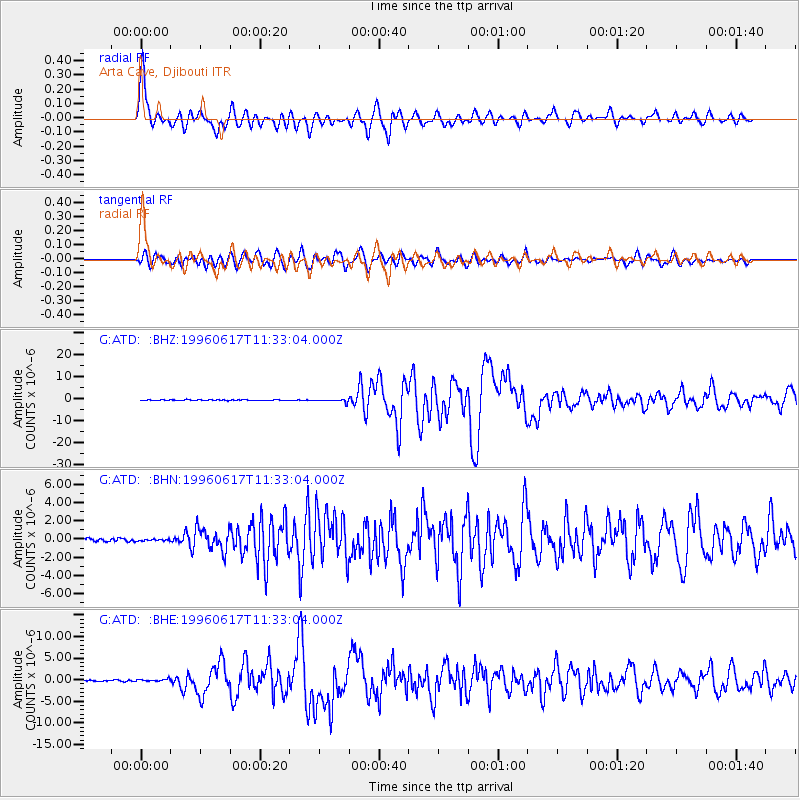
Signal To Noise
| Channel | StoN | STA | LTA |
| G:ATD: :BHN:19960617T11:33:04.000Z | 0.6960492 | 1.247112E-7 | 1.7917009E-7 |
| G:ATD: :BHE:19960617T11:33:04.000Z | 1.5684198 | 2.7247668E-7 | 1.7372689E-7 |
| G:ATD: :BHZ:19960617T11:33:04.000Z | 3.976241 | 6.8172864E-7 | 1.7145054E-7 |
| Arrivals |
| Ps | 2.9 SECOND |
| PpPs | 10 SECOND |
| PsPs/PpSs | 13 SECOND |


