You are here: Home > Network List > G - GEOSCOPE Stations List
> Station INU Inuyama, Japan > Earthquake Result Viewer
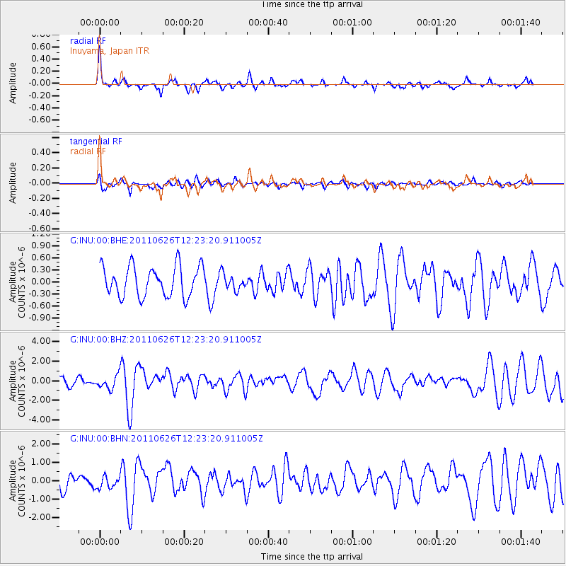
INU Inuyama, Japan - Earthquake Result Viewer
*The percent match for this event was below the threshold and hence no stack was calculated.
| Earthquake location: |
Irian Jaya Region, Indonesia |
| Earthquake latitude/longitude: |
-2.4/136.6 |
| Earthquake time(UTC): |
2011/06/26 (177) 12:16:38 GMT |
| Earthquake Depth: |
17 km |
| Earthquake Magnitude: |
6.0 MB, 6.4 MS, 6.4 MW, 6.4 MW |
| Earthquake Catalog/Contributor: |
WHDF/NEIC |
|
| Network: |
G GEOSCOPE |
| Station: |
INU Inuyama, Japan |
| Lat/Lon: |
35.35 N/137.03 E |
| Elevation: |
132 m |
|
| Distance: |
37.5 deg |
| Az: |
0.534 deg |
| Baz: |
180.653 deg |
| Ray Param: |
$rayparam |
*The percent match for this event was below the threshold and hence was not used in the summary stack. |
|
| Radial Match: |
73.132706 % |
| Radial Bump: |
307 |
| Transverse Match: |
46.187042 % |
| Transverse Bump: |
400 |
| SOD ConfigId: |
395004 |
| Insert Time: |
2011-12-08 05:07:49.606 +0000 |
| GWidth: |
2.5 |
| Max Bumps: |
400 |
| Tol: |
0.001 |
|
Signal To Noise
| Channel | StoN | STA | LTA |
| G:INU:00:BHZ:20110626T12:23:20.911005Z | 2.0156488 | 7.2667297E-7 | 3.6051563E-7 |
| G:INU:00:BHN:20110626T12:23:20.911005Z | 0.7908298 | 3.2284075E-7 | 4.082304E-7 |
| G:INU:00:BHE:20110626T12:23:20.911005Z | 0.49883193 | 1.8804661E-7 | 3.7697387E-7 |
| Arrivals |
| Ps | |
| PpPs | |
| PsPs/PpSs | |


