You are here: Home > Network List > G - GEOSCOPE Stations List
> Station ATD Arta Cave, Djibouti > Earthquake Result Viewer
ATD Arta Cave, Djibouti - Earthquake Result Viewer
| Earthquake location: |
Mindanao, Philippines |
| Earthquake latitude/longitude: |
9.6/126.3 |
| Earthquake time(UTC): |
1996/09/20 (264) 00:03:18 GMT |
| Earthquake Depth: |
33 km |
| Earthquake Magnitude: |
5.8 MB, 6.2 MS, 6.4 UNKNOWN, 6.4 MW |
| Earthquake Catalog/Contributor: |
WHDF/NEIC |
|
| Network: |
G GEOSCOPE |
| Station: |
ATD Arta Cave, Djibouti |
| Lat/Lon: |
11.53 N/42.85 E |
| Elevation: |
610 m |
|
| Distance: |
81.8 deg |
| Az: |
280.321 deg |
| Baz: |
81.869 deg |
| Ray Param: |
0.047311153 |
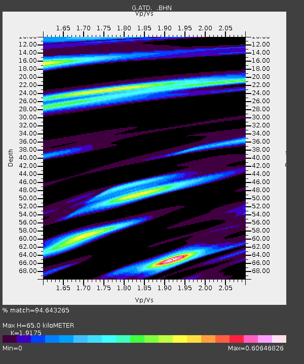
| Estimated Moho Depth: |
65.0 km |
| Estimated Crust Vp/Vs: |
1.92 |
| Assumed Crust Vp: |
6.375 km/s |
| Estimated Crust Vs: |
3.325 km/s |
| Estimated Crust Poisson's Ratio: |
0.31 |
|
| Radial Match: |
94.643265 % |
| Radial Bump: |
326 |
| Transverse Match: |
77.89294 % |
| Transverse Bump: |
400 |
| SOD ConfigId: |
6273 |
| Insert Time: |
2010-02-26 21:28:28.687 +0000 |
| GWidth: |
2.5 |
| Max Bumps: |
400 |
| Tol: |
0.001 |
|
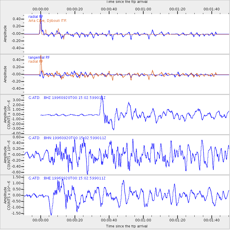
Signal To Noise
| Channel | StoN | STA | LTA |
| G:ATD: :BHN:19960920T00:15:02.599011Z | 1.182241 | 1.2039347E-7 | 1.0183497E-7 |
| G:ATD: :BHE:19960920T00:15:02.599011Z | 0.70223683 | 6.623406E-8 | 9.4318686E-8 |
| G:ATD: :BHZ:19960920T00:15:02.599011Z | 2.3477628 | 2.2306982E-7 | 9.5013775E-8 |
| Arrivals |
| Ps | 9.6 SECOND |
| PpPs | 29 SECOND |
| PsPs/PpSs | 39 SECOND |


