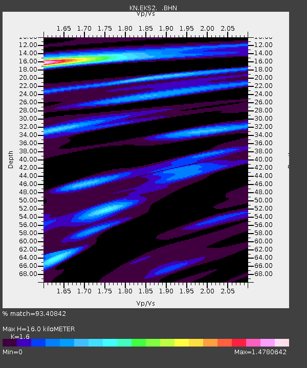
EKS2 KN.EKS2 - Earthquake Result Viewer
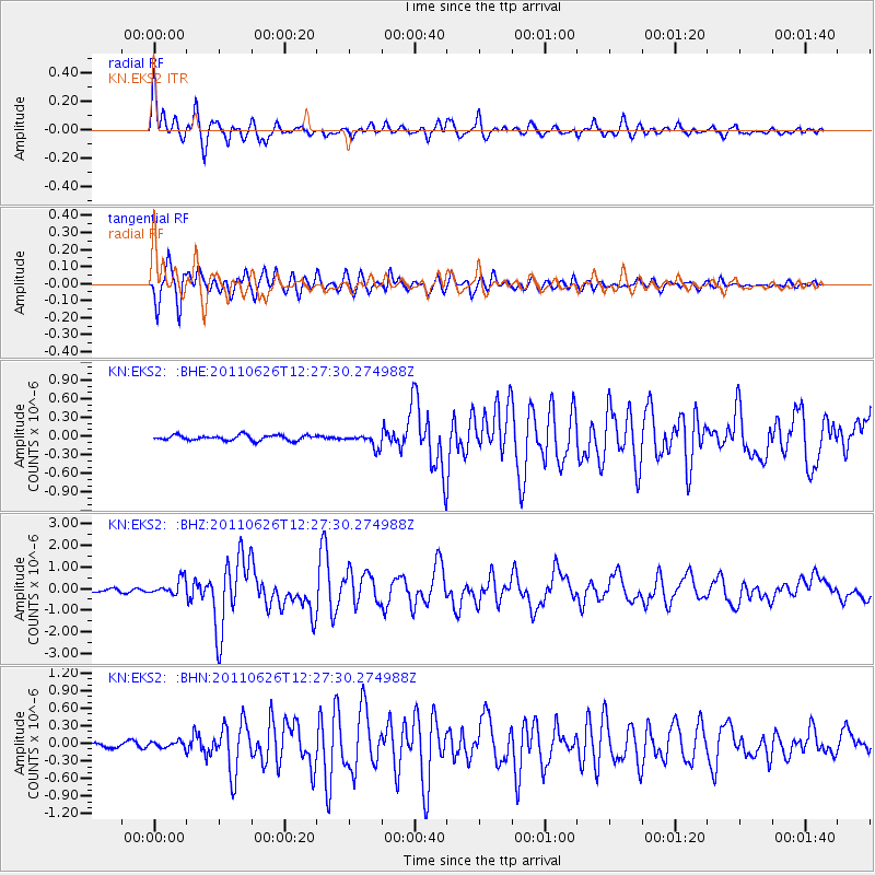
Earthquake location: Irian Jaya Region, Indonesia
Earthquake latitude/longitude: -2.4/136.6
Earthquake time(UTC): 2011/06/26 (177) 12:16:38 GMT
Earthquake Depth: 17 km
Earthquake Magnitude: 6.0 MB, 6.4 MS, 6.4 MW, 6.4 MW
Earthquake Catalog/Contributor: WHDF/NEIC
Network: KN Kyrgyz Seismic Telemetry Network
Station: EKS2 KN.EKS2
Lat/Lon: 42.66 N/73.78 E
Elevation: 1360 m
Distance: 72.0 deg
Az: 316.369 deg
Baz: 110.831 deg
Ray Param: 0.053912625
Estimated Moho Depth: 16.0 km
Estimated Crust Vp/Vs: 1.60
Assumed Crust Vp: 6.316 km/s
Estimated Crust Vs: 3.947 km/s
Estimated Crust Poisson's Ratio: 0.18
Radial Match: 93.40842 %
Radial Bump: 400
Transverse Match: 92.68744 %
Transverse Bump: 379
SOD ConfigId: 395004
Insert Time: 2011-12-08 05:09:47.215 +0000
GWidth: 2.5
Max Bumps: 400
Tol: 0.001

Signal To Noise

ChannelStoNSTALTA
KN:EKS2: :BHZ:20110626T12:27:30.274988Z4.8296963.5937978E-77.441044E-8
KN:EKS2: :BHN:20110626T12:27:30.274988Z1.37465585.2800857E-83.8410235E-8
KN:EKS2: :BHE:20110626T12:27:30.274988Z2.55660941.0578409E-74.1376712E-8
Arrivals
Ps1.6 SECOND
PpPs6.3 SECOND
PsPs/PpSs7.9 SECOND