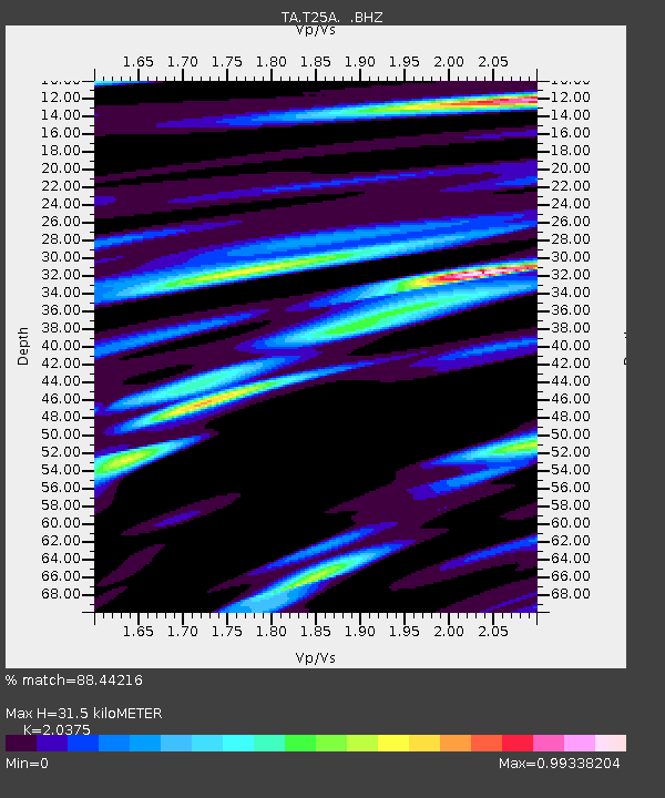
T25A Trinidad, CO, USA - Earthquake Result Viewer
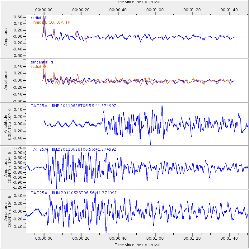
Earthquake location: Fox Islands, Aleutian Islands
Earthquake latitude/longitude: 52.1/-171.7
Earthquake time(UTC): 2011/06/28 (179) 06:48:32 GMT
Earthquake Depth: 30 km
Earthquake Magnitude: 5.6 MB, 5.4 MS, 5.9 MW, 5.6 MW
Earthquake Catalog/Contributor: WHDF/NEIC
Network: TA USArray Transportable Network (new EarthScope stations)
Station: T25A Trinidad, CO, USA
Lat/Lon: 37.14 N/104.41 W
Elevation: 2017 m
Distance: 48.4 deg
Az: 80.137 deg
Baz: 310.472 deg
Ray Param: 0.06930552
Estimated Moho Depth: 31.5 km
Estimated Crust Vp/Vs: 2.04
Assumed Crust Vp: 6.316 km/s
Estimated Crust Vs: 3.1 km/s
Estimated Crust Poisson's Ratio: 0.34
Radial Match: 88.44216 %
Radial Bump: 400
Transverse Match: 78.57851 %
Transverse Bump: 400
SOD ConfigId: 395004
Insert Time: 2011-12-08 05:43:39.751 +0000
GWidth: 2.5
Max Bumps: 400
Tol: 0.001

Signal To Noise

ChannelStoNSTALTA
TA:T25A: :BHZ:20110628T06:56:41.37499Z6.765224.804046E-77.101094E-8
TA:T25A: :BHN:20110628T06:56:41.37499Z3.03507881.9455292E-76.410144E-8
TA:T25A: :BHE:20110628T06:56:41.37499Z3.24748591.4871223E-74.5793033E-8
Arrivals
Ps5.4 SECOND
PpPs14 SECOND
PsPs/PpSs20 SECOND