You are here: Home > Network List > TA - USArray Transportable Network (new EarthScope stations) Stations List
> Station D29A Pettibone, Tappen, ND, USA > Earthquake Result Viewer
D29A Pettibone, Tappen, ND, USA - Earthquake Result Viewer
| Earthquake location: |
Fox Islands, Aleutian Islands |
| Earthquake latitude/longitude: |
52.1/-171.7 |
| Earthquake time(UTC): |
2011/06/28 (179) 06:48:32 GMT |
| Earthquake Depth: |
30 km |
| Earthquake Magnitude: |
5.6 MB, 5.4 MS, 5.9 MW, 5.6 MW |
| Earthquake Catalog/Contributor: |
WHDF/NEIC |
|
| Network: |
TA USArray Transportable Network (new EarthScope stations) |
| Station: |
D29A Pettibone, Tappen, ND, USA |
| Lat/Lon: |
47.06 N/99.60 W |
| Elevation: |
551 m |
|
| Distance: |
45.3 deg |
| Az: |
66.344 deg |
| Baz: |
304.24 deg |
| Ray Param: |
0.07133824 |
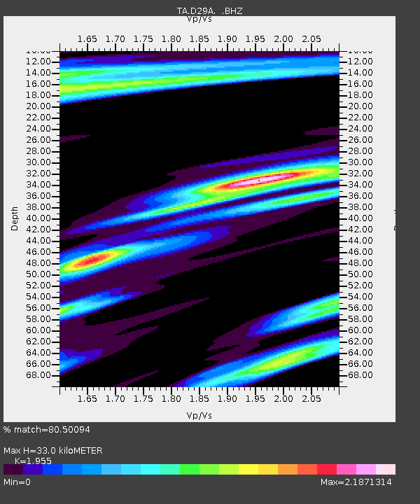
| Estimated Moho Depth: |
33.0 km |
| Estimated Crust Vp/Vs: |
1.96 |
| Assumed Crust Vp: |
6.53 km/s |
| Estimated Crust Vs: |
3.34 km/s |
| Estimated Crust Poisson's Ratio: |
0.32 |
|
| Radial Match: |
80.50094 % |
| Radial Bump: |
400 |
| Transverse Match: |
61.3947 % |
| Transverse Bump: |
394 |
| SOD ConfigId: |
395004 |
| Insert Time: |
2011-12-08 05:45:31.278 +0000 |
| GWidth: |
2.5 |
| Max Bumps: |
400 |
| Tol: |
0.001 |
|

Signal To Noise
| Channel | StoN | STA | LTA |
| TA:D29A: :BHZ:20110628T06:56:16.575002Z | 10.3437195 | 1.1617747E-6 | 1.1231691E-7 |
| TA:D29A: :BHN:20110628T06:56:16.575002Z | 1.3314416 | 3.7832456E-7 | 2.8414655E-7 |
| TA:D29A: :BHE:20110628T06:56:16.575002Z | 4.2929544 | 7.8050476E-7 | 1.8181062E-7 |
| Arrivals |
| Ps | 5.1 SECOND |
| PpPs | 14 SECOND |
| PsPs/PpSs | 19 SECOND |


