You are here: Home > Network List > G - GEOSCOPE Stations List
> Station CAN Canberra, Australia > Earthquake Result Viewer
CAN Canberra, Australia - Earthquake Result Viewer
| Earthquake location: |
Samar, Philippines |
| Earthquake latitude/longitude: |
12.0/125.7 |
| Earthquake time(UTC): |
1995/04/21 (111) 00:09:56 GMT |
| Earthquake Depth: |
33 km |
| Earthquake Magnitude: |
6.1 MB, 6.9 MS, 6.9 UNKNOWN, 6.8 MW |
| Earthquake Catalog/Contributor: |
WHDF/NEIC |
|
| Network: |
G GEOSCOPE |
| Station: |
CAN Canberra, Australia |
| Lat/Lon: |
35.32 S/149.00 E |
| Elevation: |
650 m |
|
| Distance: |
52.0 deg |
| Az: |
155.757 deg |
| Baz: |
330.575 deg |
| Ray Param: |
0.0669946 |
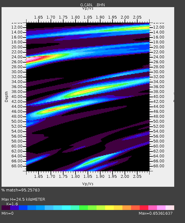
| Estimated Moho Depth: |
24.5 km |
| Estimated Crust Vp/Vs: |
1.60 |
| Assumed Crust Vp: |
6.633 km/s |
| Estimated Crust Vs: |
4.146 km/s |
| Estimated Crust Poisson's Ratio: |
0.18 |
|
| Radial Match: |
95.25763 % |
| Radial Bump: |
304 |
| Transverse Match: |
81.29907 % |
| Transverse Bump: |
400 |
| SOD ConfigId: |
4480 |
| Insert Time: |
2010-02-26 21:29:12.638 +0000 |
| GWidth: |
2.5 |
| Max Bumps: |
400 |
| Tol: |
0.001 |
|

Signal To Noise
| Channel | StoN | STA | LTA |
| G:CAN: :BHN:19950421T00:18:31.520007Z | 11.029364 | 4.7495805E-6 | 4.306305E-7 |
| G:CAN: :BHE:19950421T00:18:31.520007Z | 6.6378384 | 2.1847943E-6 | 3.2914244E-7 |
| G:CAN: :BHZ:19950421T00:18:31.520007Z | 3.5945976 | 1.2236259E-6 | 3.4040693E-7 |
| Arrivals |
| Ps | 2.4 SECOND |
| PpPs | 9.0 SECOND |
| PsPs/PpSs | 11 SECOND |


