You are here: Home > Network List > TA - USArray Transportable Network (new EarthScope stations) Stations List
> Station P34A Walnut Farm, Randolph, KS, USA > Earthquake Result Viewer
P34A Walnut Farm, Randolph, KS, USA - Earthquake Result Viewer
| Earthquake location: |
Fox Islands, Aleutian Islands |
| Earthquake latitude/longitude: |
52.1/-171.7 |
| Earthquake time(UTC): |
2011/06/28 (179) 06:48:32 GMT |
| Earthquake Depth: |
30 km |
| Earthquake Magnitude: |
5.6 MB, 5.4 MS, 5.9 MW, 5.6 MW |
| Earthquake Catalog/Contributor: |
WHDF/NEIC |
|
| Network: |
TA USArray Transportable Network (new EarthScope stations) |
| Station: |
P34A Walnut Farm, Randolph, KS, USA |
| Lat/Lon: |
39.55 N/96.83 W |
| Elevation: |
429 m |
|
| Distance: |
51.4 deg |
| Az: |
72.696 deg |
| Baz: |
310.367 deg |
| Ray Param: |
0.06737008 |
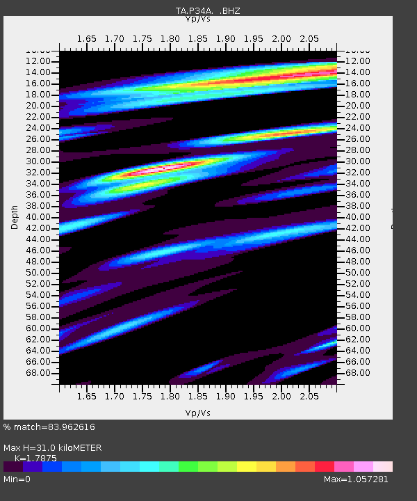
| Estimated Moho Depth: |
31.0 km |
| Estimated Crust Vp/Vs: |
1.79 |
| Assumed Crust Vp: |
6.483 km/s |
| Estimated Crust Vs: |
3.627 km/s |
| Estimated Crust Poisson's Ratio: |
0.27 |
|
| Radial Match: |
83.962616 % |
| Radial Bump: |
400 |
| Transverse Match: |
59.013615 % |
| Transverse Bump: |
400 |
| SOD ConfigId: |
395004 |
| Insert Time: |
2011-12-08 05:56:08.255 +0000 |
| GWidth: |
2.5 |
| Max Bumps: |
400 |
| Tol: |
0.001 |
|

Signal To Noise
| Channel | StoN | STA | LTA |
| TA:P34A: :BHZ:20110628T06:57:04.025015Z | 5.9581294 | 4.0415108E-7 | 6.783188E-8 |
| TA:P34A: :BHN:20110628T06:57:04.025015Z | 3.0297818 | 1.8384804E-7 | 6.068029E-8 |
| TA:P34A: :BHE:20110628T06:57:04.025015Z | 3.6673126 | 2.2760025E-7 | 6.206186E-8 |
| Arrivals |
| Ps | 4.0 SECOND |
| PpPs | 13 SECOND |
| PsPs/PpSs | 17 SECOND |


