You are here: Home > Network List > TA - USArray Transportable Network (new EarthScope stations) Stations List
> Station P36A Good Intent, Atchison, KS, USA > Earthquake Result Viewer
P36A Good Intent, Atchison, KS, USA - Earthquake Result Viewer
| Earthquake location: |
Fox Islands, Aleutian Islands |
| Earthquake latitude/longitude: |
52.1/-171.7 |
| Earthquake time(UTC): |
2011/06/28 (179) 06:48:32 GMT |
| Earthquake Depth: |
30 km |
| Earthquake Magnitude: |
5.6 MB, 5.4 MS, 5.9 MW, 5.6 MW |
| Earthquake Catalog/Contributor: |
WHDF/NEIC |
|
| Network: |
TA USArray Transportable Network (new EarthScope stations) |
| Station: |
P36A Good Intent, Atchison, KS, USA |
| Lat/Lon: |
39.62 N/95.21 W |
| Elevation: |
313 m |
|
| Distance: |
52.3 deg |
| Az: |
71.59 deg |
| Baz: |
310.713 deg |
| Ray Param: |
0.066776484 |
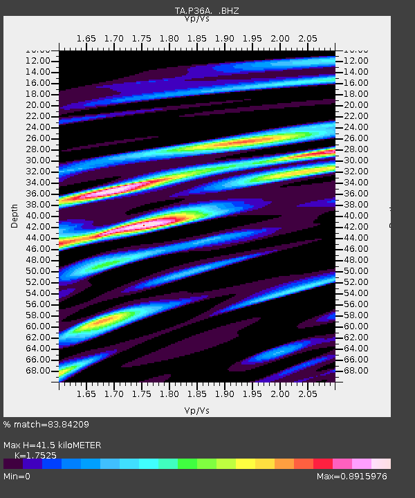
| Estimated Moho Depth: |
41.5 km |
| Estimated Crust Vp/Vs: |
1.75 |
| Assumed Crust Vp: |
6.498 km/s |
| Estimated Crust Vs: |
3.708 km/s |
| Estimated Crust Poisson's Ratio: |
0.26 |
|
| Radial Match: |
83.84209 % |
| Radial Bump: |
400 |
| Transverse Match: |
65.69995 % |
| Transverse Bump: |
400 |
| SOD ConfigId: |
395004 |
| Insert Time: |
2011-12-08 05:56:08.884 +0000 |
| GWidth: |
2.5 |
| Max Bumps: |
400 |
| Tol: |
0.001 |
|

Signal To Noise
| Channel | StoN | STA | LTA |
| TA:P36A: :BHZ:20110628T06:57:10.74999Z | 10.101249 | 6.0064207E-7 | 5.9462163E-8 |
| TA:P36A: :BHN:20110628T06:57:10.74999Z | 3.9098673 | 2.7479263E-7 | 7.028183E-8 |
| TA:P36A: :BHE:20110628T06:57:10.74999Z | 3.725337 | 2.8540524E-7 | 7.661192E-8 |
| Arrivals |
| Ps | 5.1 SECOND |
| PpPs | 17 SECOND |
| PsPs/PpSs | 22 SECOND |


