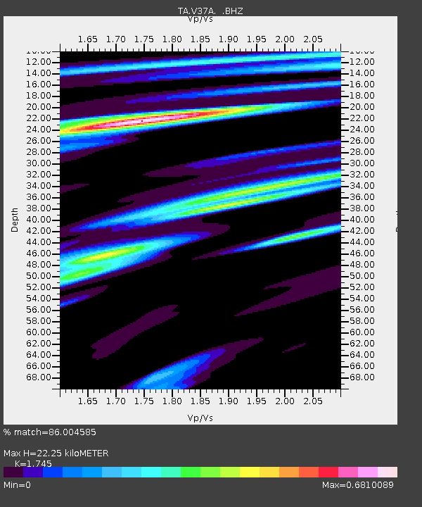
V37A Hulbert, OK, USA - Earthquake Result Viewer

Earthquake location: Fox Islands, Aleutian Islands
Earthquake latitude/longitude: 52.1/-171.7
Earthquake time(UTC): 2011/06/28 (179) 06:48:32 GMT
Earthquake Depth: 30 km
Earthquake Magnitude: 5.6 MB, 5.4 MS, 5.9 MW, 5.6 MW
Earthquake Catalog/Contributor: WHDF/NEIC
Network: TA USArray Transportable Network (new EarthScope stations)
Station: V37A Hulbert, OK, USA
Lat/Lon: 35.88 N/95.14 W
Elevation: 219 m
Distance: 54.9 deg
Az: 75.006 deg
Baz: 312.782 deg
Ray Param: 0.0651291
Estimated Moho Depth: 22.25 km
Estimated Crust Vp/Vs: 1.75
Assumed Crust Vp: 6.498 km/s
Estimated Crust Vs: 3.724 km/s
Estimated Crust Poisson's Ratio: 0.26
Radial Match: 86.004585 %
Radial Bump: 395
Transverse Match: 75.48034 %
Transverse Bump: 400
SOD ConfigId: 395004
Insert Time: 2011-12-08 05:56:59.458 +0000
GWidth: 2.5
Max Bumps: 400
Tol: 0.001

Signal To Noise

ChannelStoNSTALTA
TA:V37A: :BHZ:20110628T06:57:29.200002Z7.03992753.1579157E-74.485722E-8
TA:V37A: :BHN:20110628T06:57:29.200002Z3.1140321.3276643E-74.2634895E-8
TA:V37A: :BHE:20110628T06:57:29.200002Z6.07769161.2284943E-72.0213173E-8
Arrivals
Ps2.7 SECOND
PpPs8.9 SECOND
PsPs/PpSs12 SECOND