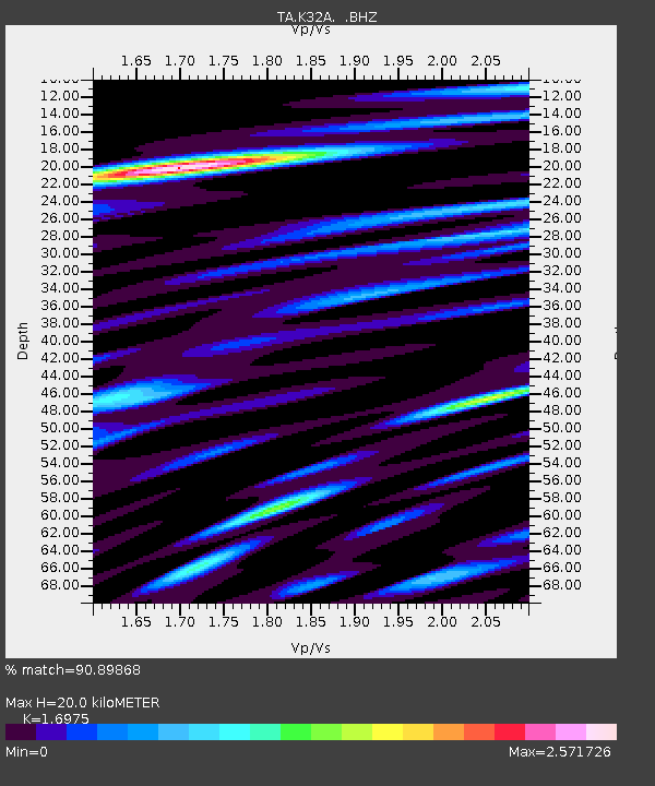
K32A Verdigre, NE, USA - Earthquake Result Viewer
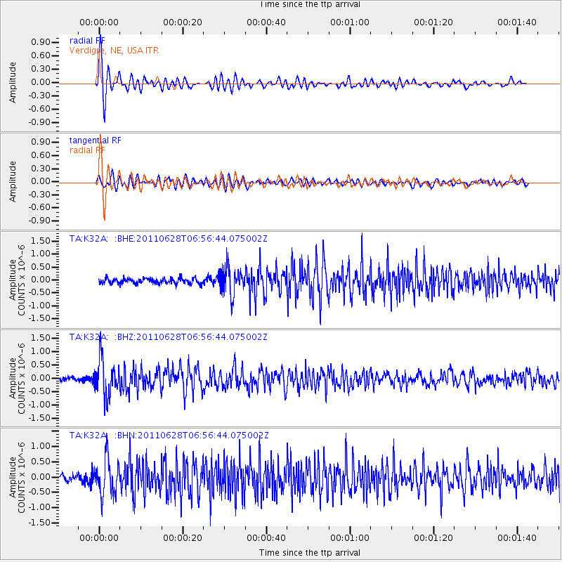
Earthquake location: Fox Islands, Aleutian Islands
Earthquake latitude/longitude: 52.1/-171.7
Earthquake time(UTC): 2011/06/28 (179) 06:48:32 GMT
Earthquake Depth: 30 km
Earthquake Magnitude: 5.6 MB, 5.4 MS, 5.9 MW, 5.6 MW
Earthquake Catalog/Contributor: WHDF/NEIC
Network: TA USArray Transportable Network (new EarthScope stations)
Station: K32A Verdigre, NE, USA
Lat/Lon: 42.66 N/97.97 W
Elevation: 512 m
Distance: 48.8 deg
Az: 70.269 deg
Baz: 308.06 deg
Ray Param: 0.06907109
Estimated Moho Depth: 20.0 km
Estimated Crust Vp/Vs: 1.70
Assumed Crust Vp: 6.498 km/s
Estimated Crust Vs: 3.828 km/s
Estimated Crust Poisson's Ratio: 0.23
Radial Match: 90.89868 %
Radial Bump: 400
Transverse Match: 74.77792 %
Transverse Bump: 400
SOD ConfigId: 395004
Insert Time: 2011-12-08 05:57:55.406 +0000
GWidth: 2.5
Max Bumps: 400
Tol: 0.001

Signal To Noise

ChannelStoNSTALTA
TA:K32A: :BHZ:20110628T06:56:44.075002Z9.7563737.0975364E-77.274769E-8
TA:K32A: :BHN:20110628T06:56:44.075002Z5.4993355.9329363E-71.0788462E-7
TA:K32A: :BHE:20110628T06:56:44.075002Z5.35037855.3486457E-79.996762E-8
Arrivals
Ps2.3 SECOND
PpPs7.8 SECOND
PsPs/PpSs10 SECOND