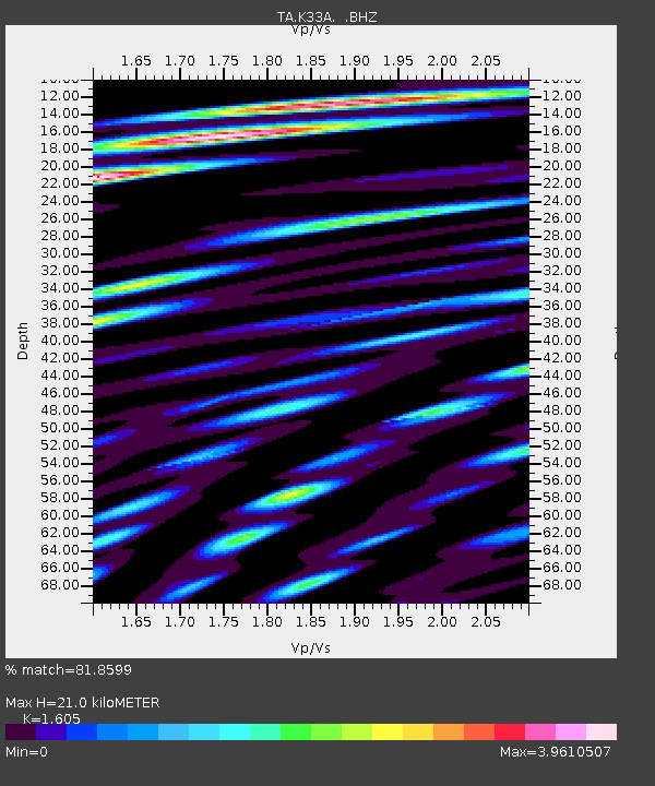
K33A Hardington, NE, USA - Earthquake Result Viewer
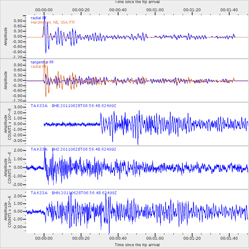
Earthquake location: Fox Islands, Aleutian Islands
Earthquake latitude/longitude: 52.1/-171.7
Earthquake time(UTC): 2011/06/28 (179) 06:48:32 GMT
Earthquake Depth: 30 km
Earthquake Magnitude: 5.6 MB, 5.4 MS, 5.9 MW, 5.6 MW
Earthquake Catalog/Contributor: WHDF/NEIC
Network: TA USArray Transportable Network (new EarthScope stations)
Station: K33A Hardington, NE, USA
Lat/Lon: 42.61 N/97.00 W
Elevation: 507 m
Distance: 49.4 deg
Az: 69.739 deg
Baz: 308.368 deg
Ray Param: 0.068680346
Estimated Moho Depth: 21.0 km
Estimated Crust Vp/Vs: 1.61
Assumed Crust Vp: 6.498 km/s
Estimated Crust Vs: 4.048 km/s
Estimated Crust Poisson's Ratio: 0.18
Radial Match: 81.8599 %
Radial Bump: 400
Transverse Match: 76.15373 %
Transverse Bump: 400
SOD ConfigId: 395004
Insert Time: 2011-12-08 05:58:07.486 +0000
GWidth: 2.5
Max Bumps: 400
Tol: 0.001

Signal To Noise

ChannelStoNSTALTA
TA:K33A: :BHZ:20110628T06:56:48.62499Z7.9009489.2538994E-71.1712391E-7
TA:K33A: :BHN:20110628T06:56:48.62499Z3.94348965.50281E-71.3954164E-7
TA:K33A: :BHE:20110628T06:56:48.62499Z5.38037637.911947E-71.4705192E-7
Arrivals
Ps2.1 SECOND
PpPs7.9 SECOND
PsPs/PpSs10.0 SECOND