You are here: Home > Network List > TA - USArray Transportable Network (new EarthScope stations) Stations List
> Station I32A Karley and Nick, Howard, SD, USA > Earthquake Result Viewer
I32A Karley and Nick, Howard, SD, USA - Earthquake Result Viewer
| Earthquake location: |
Fox Islands, Aleutian Islands |
| Earthquake latitude/longitude: |
52.1/-171.7 |
| Earthquake time(UTC): |
2011/06/28 (179) 06:48:32 GMT |
| Earthquake Depth: |
30 km |
| Earthquake Magnitude: |
5.6 MB, 5.4 MS, 5.9 MW, 5.6 MW |
| Earthquake Catalog/Contributor: |
WHDF/NEIC |
|
| Network: |
TA USArray Transportable Network (new EarthScope stations) |
| Station: |
I32A Karley and Nick, Howard, SD, USA |
| Lat/Lon: |
44.03 N/97.46 W |
| Elevation: |
493 m |
|
| Distance: |
48.2 deg |
| Az: |
68.522 deg |
| Baz: |
307.25 deg |
| Ray Param: |
0.06942945 |
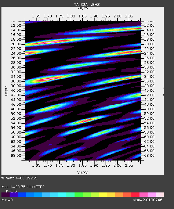
| Estimated Moho Depth: |
23.75 km |
| Estimated Crust Vp/Vs: |
1.60 |
| Assumed Crust Vp: |
6.552 km/s |
| Estimated Crust Vs: |
4.095 km/s |
| Estimated Crust Poisson's Ratio: |
0.18 |
|
| Radial Match: |
80.39265 % |
| Radial Bump: |
400 |
| Transverse Match: |
79.89292 % |
| Transverse Bump: |
400 |
| SOD ConfigId: |
395004 |
| Insert Time: |
2011-12-08 05:58:21.439 +0000 |
| GWidth: |
2.5 |
| Max Bumps: |
400 |
| Tol: |
0.001 |
|
Signal To Noise
| Channel | StoN | STA | LTA |
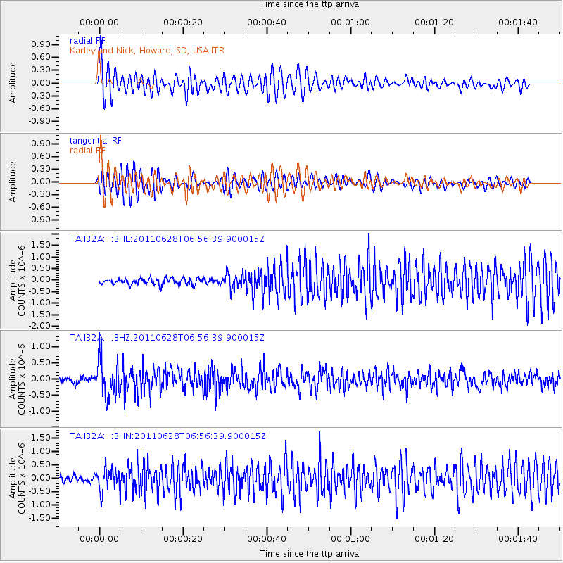
| TA:I32A: :BHZ:20110628T06:56:39.900015Z | 5.57172 | 5.7413297E-7 | 1.0304412E-7 |
| TA:I32A: :BHN:20110628T06:56:39.900015Z | 3.3497663 | 3.836225E-7 | 1.1452217E-7 |
| TA:I32A: :BHE:20110628T06:56:39.900015Z | 2.3834558 | 2.9367638E-7 | 1.2321453E-7 |
| Arrivals |
| Ps | 2.3 SECOND |
| PpPs | 8.8 SECOND |
| PsPs/PpSs | 11 SECOND |


