You are here: Home > Network List > TA - USArray Transportable Network (new EarthScope stations) Stations List
> Station I35A Creekview Farms, Bingham Lake, MN, USA > Earthquake Result Viewer
I35A Creekview Farms, Bingham Lake, MN, USA - Earthquake Result Viewer

| Earthquake location: |
Fox Islands, Aleutian Islands |
| Earthquake latitude/longitude: |
52.1/-171.7 |
| Earthquake time(UTC): |
2011/06/28 (179) 06:48:32 GMT |
| Earthquake Depth: |
30 km |
| Earthquake Magnitude: |
5.6 MB, 5.4 MS, 5.9 MW, 5.6 MW |
| Earthquake Catalog/Contributor: |
WHDF/NEIC |
|
| Network: |
TA USArray Transportable Network (new EarthScope stations) |
| Station: |
I35A Creekview Farms, Bingham Lake, MN, USA |
| Lat/Lon: |
43.86 N/94.98 W |
| Elevation: |
428 m |
|
| Distance: |
49.8 deg |
| Az: |
67.249 deg |
| Baz: |
308.131 deg |
| Ray Param: |
0.068436265 |
| Estimated Moho Depth: |
42.5 km |
| Estimated Crust Vp/Vs: |
1.75 |
| Assumed Crust Vp: |
6.53 km/s |
| Estimated Crust Vs: |
3.726 km/s |
| Estimated Crust Poisson's Ratio: |
0.26 |
|
| Radial Match: |
80.00552 % |
| Radial Bump: |
400 |
| Transverse Match: |
65.51212 % |
| Transverse Bump: |
400 |
| SOD ConfigId: |
395004 |
| Insert Time: |
2011-12-08 05:58:45.980 +0000 |
| GWidth: |
2.5 |
| Max Bumps: |
400 |
| Tol: |
0.001 |
|
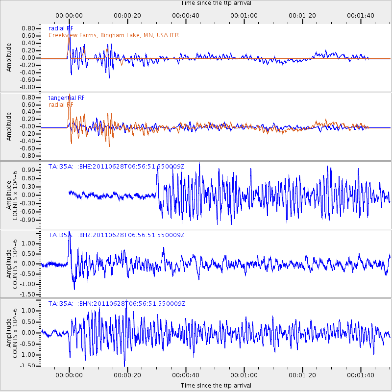
Signal To Noise
| Channel | StoN | STA | LTA |
| TA:I35A: :BHZ:20110628T06:56:51.550009Z | 12.893549 | 6.8811005E-7 | 5.3368556E-8 |
| TA:I35A: :BHN:20110628T06:56:51.550009Z | 6.3622804 | 4.36828E-7 | 6.8659034E-8 |
| TA:I35A: :BHE:20110628T06:56:51.550009Z | 6.819523 | 4.2545827E-7 | 6.2388274E-8 |
| Arrivals |
| Ps | 5.2 SECOND |
| PpPs | 17 SECOND |
| PsPs/PpSs | 22 SECOND |


