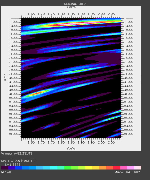
K35A Storm Lake, IA, USA - Earthquake Result Viewer
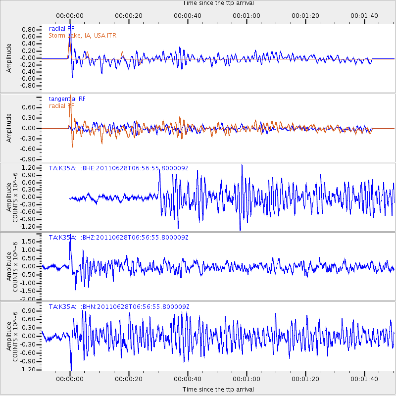
Earthquake location: Fox Islands, Aleutian Islands
Earthquake latitude/longitude: 52.1/-171.7
Earthquake time(UTC): 2011/06/28 (179) 06:48:32 GMT
Earthquake Depth: 30 km
Earthquake Magnitude: 5.6 MB, 5.4 MS, 5.9 MW, 5.6 MW
Earthquake Catalog/Contributor: WHDF/NEIC
Network: TA USArray Transportable Network (new EarthScope stations)
Station: K35A Storm Lake, IA, USA
Lat/Lon: 42.72 N/95.23 W
Elevation: 439 m
Distance: 50.3 deg
Az: 68.556 deg
Baz: 308.799 deg
Ray Param: 0.068072625
Estimated Moho Depth: 12.5 km
Estimated Crust Vp/Vs: 1.89
Assumed Crust Vp: 6.53 km/s
Estimated Crust Vs: 3.46 km/s
Estimated Crust Poisson's Ratio: 0.30
Radial Match: 82.23193 %
Radial Bump: 400
Transverse Match: 74.98962 %
Transverse Bump: 400
SOD ConfigId: 395004
Insert Time: 2011-12-08 05:58:46.436 +0000
GWidth: 2.5
Max Bumps: 400
Tol: 0.001

Signal To Noise

ChannelStoNSTALTA
TA:K35A: :BHZ:20110628T06:56:55.800009Z10.3072416.5233394E-76.3288894E-8
TA:K35A: :BHN:20110628T06:56:55.800009Z4.85224344.3462958E-78.9572914E-8
TA:K35A: :BHE:20110628T06:56:55.800009Z6.3705154.7771476E-77.498841E-8
Arrivals
Ps1.8 SECOND
PpPs5.2 SECOND
PsPs/PpSs7.0 SECOND