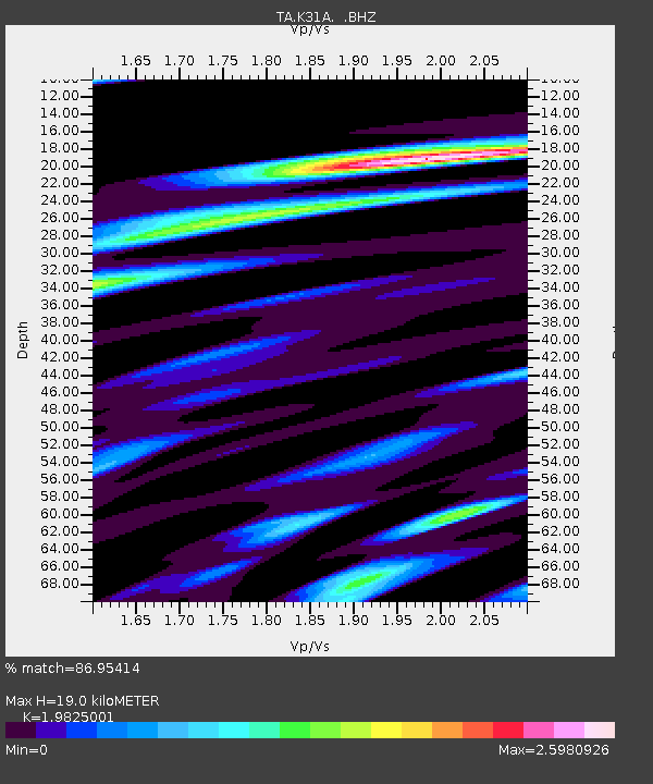
K31A O'Neill, NE, USA - Earthquake Result Viewer

Earthquake location: Fox Islands, Aleutian Islands
Earthquake latitude/longitude: 52.1/-171.7
Earthquake time(UTC): 2011/06/28 (179) 06:48:32 GMT
Earthquake Depth: 30 km
Earthquake Magnitude: 5.6 MB, 5.4 MS, 5.9 MW, 5.6 MW
Earthquake Catalog/Contributor: WHDF/NEIC
Network: TA USArray Transportable Network (new EarthScope stations)
Station: K31A O'Neill, NE, USA
Lat/Lon: 42.62 N/98.75 W
Elevation: 580 m
Distance: 48.4 deg
Az: 70.781 deg
Baz: 307.871 deg
Ray Param: 0.0693601
Estimated Moho Depth: 19.0 km
Estimated Crust Vp/Vs: 1.98
Assumed Crust Vp: 6.53 km/s
Estimated Crust Vs: 3.294 km/s
Estimated Crust Poisson's Ratio: 0.33
Radial Match: 86.95414 %
Radial Bump: 359
Transverse Match: 78.2587 %
Transverse Bump: 400
SOD ConfigId: 395004
Insert Time: 2011-12-08 06:00:15.998 +0000
GWidth: 2.5
Max Bumps: 400
Tol: 0.001

Signal To Noise

ChannelStoNSTALTA
TA:K31A: :BHZ:20110628T06:56:40.74999Z7.47979357.659853E-71.0240728E-7
TA:K31A: :BHN:20110628T06:56:40.74999Z6.76875457.4369666E-71.09872005E-7
TA:K31A: :BHE:20110628T06:56:40.74999Z6.0040466.9710467E-71.1610581E-7
Arrivals
Ps3.0 SECOND
PpPs8.2 SECOND
PsPs/PpSs11 SECOND