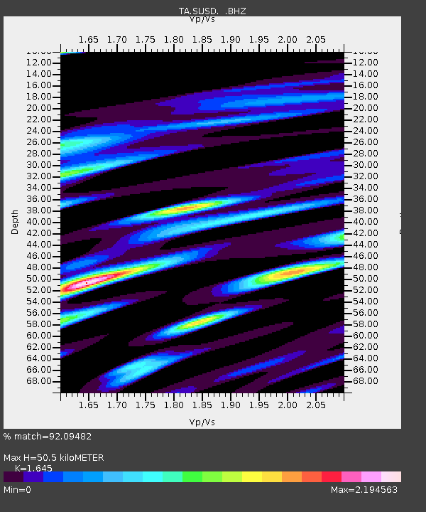
SUSD Miller, SD, USA - Earthquake Result Viewer

Earthquake location: Fox Islands, Aleutian Islands
Earthquake latitude/longitude: 52.1/-171.7
Earthquake time(UTC): 2011/06/28 (179) 06:48:32 GMT
Earthquake Depth: 30 km
Earthquake Magnitude: 5.6 MB, 5.4 MS, 5.9 MW, 5.6 MW
Earthquake Catalog/Contributor: WHDF/NEIC
Network: TA USArray Transportable Network (new EarthScope stations)
Station: SUSD Miller, SD, USA
Lat/Lon: 44.44 N/98.96 W
Elevation: 520 m
Distance: 47.1 deg
Az: 68.943 deg
Baz: 306.496 deg
Ray Param: 0.07013081
Estimated Moho Depth: 50.5 km
Estimated Crust Vp/Vs: 1.64
Assumed Crust Vp: 6.53 km/s
Estimated Crust Vs: 3.97 km/s
Estimated Crust Poisson's Ratio: 0.21
Radial Match: 92.09482 %
Radial Bump: 398
Transverse Match: 58.91086 %
Transverse Bump: 400
SOD ConfigId: 395004
Insert Time: 2011-12-08 06:03:34.517 +0000
GWidth: 2.5
Max Bumps: 400
Tol: 0.001

Signal To Noise

ChannelStoNSTALTA
TA:SUSD: :BHZ:20110628T06:56:31.349996Z15.6269249.878129E-76.321224E-8
TA:SUSD: :BHN:20110628T06:56:31.349996Z3.41426135.975276E-71.7500933E-7
TA:SUSD: :BHE:20110628T06:56:31.349996Z6.6959011.1864219E-61.771863E-7
Arrivals
Ps5.3 SECOND
PpPs19 SECOND
PsPs/PpSs24 SECOND