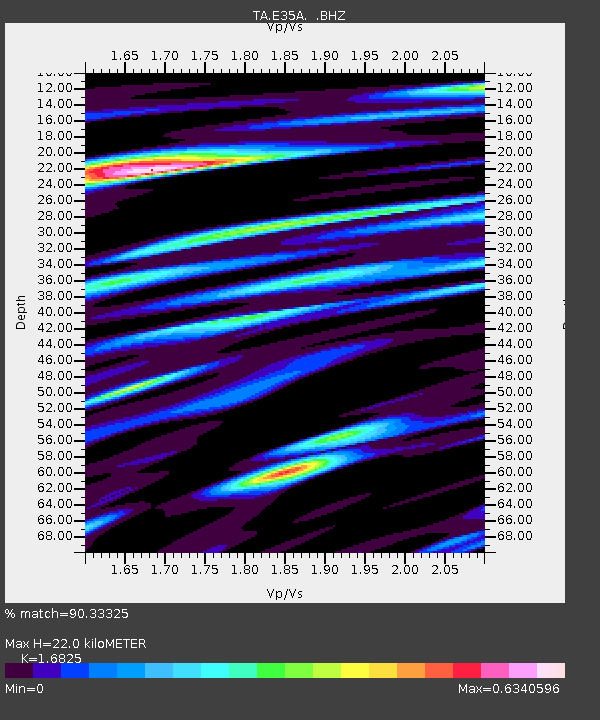
E35A Pequot Lakes, MN, USA - Earthquake Result Viewer

Earthquake location: Fox Islands, Aleutian Islands
Earthquake latitude/longitude: 52.1/-171.7
Earthquake time(UTC): 2011/06/28 (179) 06:48:32 GMT
Earthquake Depth: 30 km
Earthquake Magnitude: 5.6 MB, 5.4 MS, 5.9 MW, 5.6 MW
Earthquake Catalog/Contributor: WHDF/NEIC
Network: TA USArray Transportable Network (new EarthScope stations)
Station: E35A Pequot Lakes, MN, USA
Lat/Lon: 46.56 N/94.40 W
Elevation: 409 m
Distance: 48.5 deg
Az: 64.08 deg
Baz: 306.465 deg
Ray Param: 0.06929194
Estimated Moho Depth: 22.0 km
Estimated Crust Vp/Vs: 1.68
Assumed Crust Vp: 6.419 km/s
Estimated Crust Vs: 3.815 km/s
Estimated Crust Poisson's Ratio: 0.23
Radial Match: 90.33325 %
Radial Bump: 400
Transverse Match: 75.81886 %
Transverse Bump: 400
SOD ConfigId: 395004
Insert Time: 2011-12-08 06:03:59.498 +0000
GWidth: 2.5
Max Bumps: 400
Tol: 0.001

Signal To Noise

ChannelStoNSTALTA
TA:E35A: :BHZ:20110628T06:56:41.525015Z12.7113531.0256794E-68.069002E-8
TA:E35A: :BHN:20110628T06:56:41.525015Z11.0918285.7572663E-75.1905477E-8
TA:E35A: :BHE:20110628T06:56:41.525015Z10.6992437.223922E-76.7518066E-8
Arrivals
Ps2.5 SECOND
PpPs8.6 SECOND
PsPs/PpSs11 SECOND