D35A Remer, MN, USA - Earthquake Result Viewer
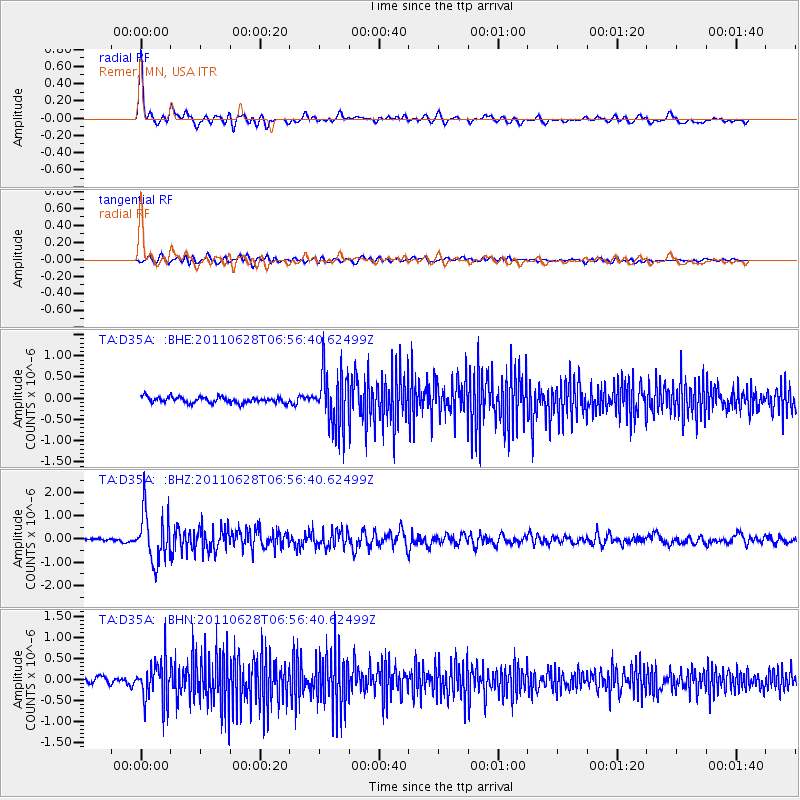
Earthquake location: Fox Islands, Aleutian Islands
Earthquake latitude/longitude: 52.1/-171.7
Earthquake time(UTC): 2011/06/28 (179) 06:48:32 GMT
Earthquake Depth: 30 km
Earthquake Magnitude: 5.6 MB, 5.4 MS, 5.9 MW, 5.6 MW
Earthquake Catalog/Contributor: WHDF/NEIC
Network: TA USArray Transportable Network (new EarthScope stations)
Station: D35A Remer, MN, USA
Lat/Lon: 47.08 N/94.05 W
Elevation: 427 m
Distance: 48.3 deg
Az: 63.324 deg
Baz: 306.219 deg
Ray Param: 0.06936956
Estimated Moho Depth: 40.5 km
Estimated Crust Vp/Vs: 1.74
Assumed Crust Vp: 6.419 km/s
Estimated Crust Vs: 3.684 km/s
Estimated Crust Poisson's Ratio: 0.25
Radial Match: 86.59758 %
Radial Bump: 400
Transverse Match: 60.36923 %
Transverse Bump: 400
SOD ConfigId: 395004
Insert Time: 2011-12-08 06:04:38.236 +0000
GWidth: 2.5
Max Bumps: 400
Tol: 0.001

Signal To Noise

ChannelStoNSTALTA
TA:D35A: :BHZ:20110628T06:56:40.62499Z16.1784531.0561473E-66.52811E-8
TA:D35A: :BHN:20110628T06:56:40.62499Z6.42500264.8870214E-77.6062555E-8
TA:D35A: :BHE:20110628T06:56:40.62499Z9.4746886.6280603E-76.995545E-8
Arrivals
Ps5.0 SECOND
PpPs16 SECOND
PsPs/PpSs21 SECOND