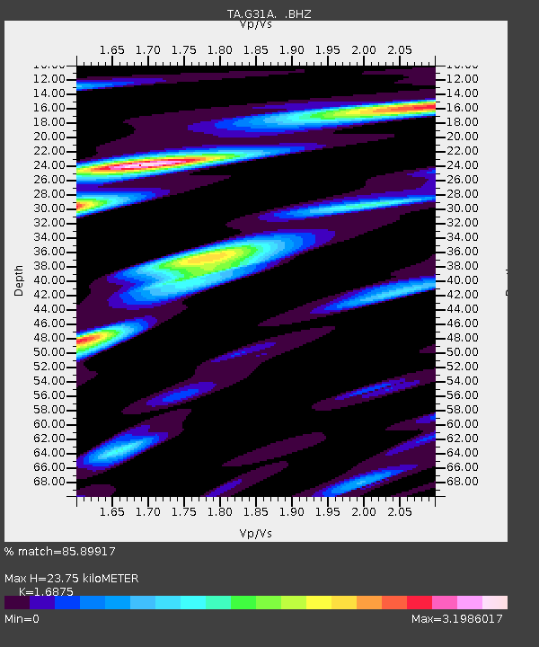
G31A Conde, SD, USA - Earthquake Result Viewer

Earthquake location: Fox Islands, Aleutian Islands
Earthquake latitude/longitude: 52.1/-171.7
Earthquake time(UTC): 2011/06/28 (179) 06:48:32 GMT
Earthquake Depth: 30 km
Earthquake Magnitude: 5.6 MB, 5.4 MS, 5.9 MW, 5.6 MW
Earthquake Catalog/Contributor: WHDF/NEIC
Network: TA USArray Transportable Network (new EarthScope stations)
Station: G31A Conde, SD, USA
Lat/Lon: 45.23 N/98.21 W
Elevation: 393 m
Distance: 47.1 deg
Az: 67.652 deg
Baz: 306.144 deg
Ray Param: 0.070154116
Estimated Moho Depth: 23.75 km
Estimated Crust Vp/Vs: 1.69
Assumed Crust Vp: 6.53 km/s
Estimated Crust Vs: 3.87 km/s
Estimated Crust Poisson's Ratio: 0.23
Radial Match: 85.89917 %
Radial Bump: 400
Transverse Match: 75.62438 %
Transverse Bump: 400
SOD ConfigId: 395004
Insert Time: 2011-12-08 06:05:04.369 +0000
GWidth: 2.5
Max Bumps: 400
Tol: 0.001

Signal To Noise

ChannelStoNSTALTA
TA:G31A: :BHZ:20110628T06:56:31.075002Z9.1106076.68071E-77.332892E-8
TA:G31A: :BHN:20110628T06:56:31.075002Z4.5241664.8049964E-71.0620733E-7
TA:G31A: :BHE:20110628T06:56:31.075002Z6.6093826.2799364E-79.501548E-8
Arrivals
Ps2.7 SECOND
PpPs9.1 SECOND
PsPs/PpSs12 SECOND