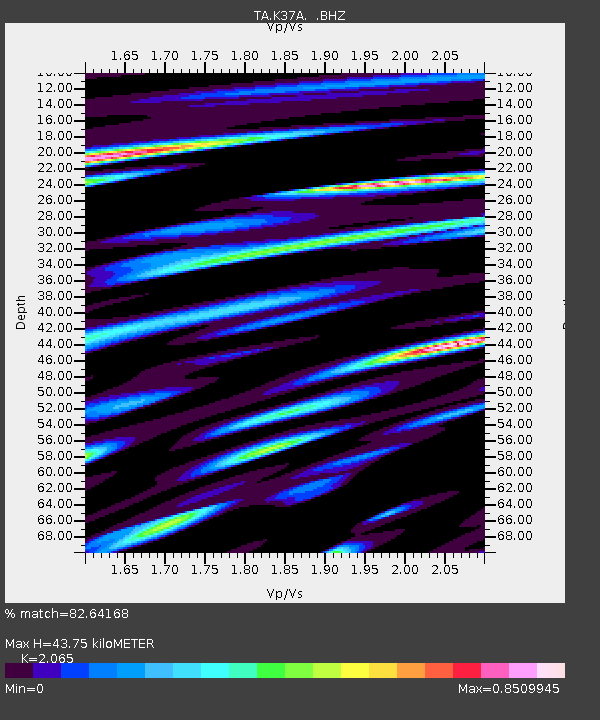
K37A Belmond, IA, USA - Earthquake Result Viewer

Earthquake location: Fox Islands, Aleutian Islands
Earthquake latitude/longitude: 52.1/-171.7
Earthquake time(UTC): 2011/06/28 (179) 06:48:32 GMT
Earthquake Depth: 30 km
Earthquake Magnitude: 5.6 MB, 5.4 MS, 5.9 MW, 5.6 MW
Earthquake Catalog/Contributor: WHDF/NEIC
Network: TA USArray Transportable Network (new EarthScope stations)
Station: K37A Belmond, IA, USA
Lat/Lon: 42.77 N/93.64 W
Elevation: 365 m
Distance: 51.2 deg
Az: 67.556 deg
Baz: 309.245 deg
Ray Param: 0.06750156
Estimated Moho Depth: 43.75 km
Estimated Crust Vp/Vs: 2.07
Assumed Crust Vp: 6.53 km/s
Estimated Crust Vs: 3.162 km/s
Estimated Crust Poisson's Ratio: 0.35
Radial Match: 82.64168 %
Radial Bump: 400
Transverse Match: 69.15776 %
Transverse Bump: 400
SOD ConfigId: 395004
Insert Time: 2011-12-08 06:06:48.168 +0000
GWidth: 2.5
Max Bumps: 400
Tol: 0.001

Signal To Noise

ChannelStoNSTALTA
TA:K37A: :BHZ:20110628T06:57:02.450002Z9.371095.926318E-76.3240435E-8
TA:K37A: :BHN:20110628T06:57:02.450002Z3.52232551.8849259E-75.351368E-8
TA:K37A: :BHE:20110628T06:57:02.450002Z4.15411142.3314384E-75.6123636E-8
Arrivals
Ps7.5 SECOND
PpPs20 SECOND
PsPs/PpSs27 SECOND