You are here: Home > Network List > TA - USArray Transportable Network (new EarthScope stations) Stations List
> Station N37A Lee Faris, Mount Ayr, IA, USA > Earthquake Result Viewer
N37A Lee Faris, Mount Ayr, IA, USA - Earthquake Result Viewer
| Earthquake location: |
Fox Islands, Aleutian Islands |
| Earthquake latitude/longitude: |
52.1/-171.7 |
| Earthquake time(UTC): |
2011/06/28 (179) 06:48:32 GMT |
| Earthquake Depth: |
30 km |
| Earthquake Magnitude: |
5.6 MB, 5.4 MS, 5.9 MW, 5.6 MW |
| Earthquake Catalog/Contributor: |
WHDF/NEIC |
|
| Network: |
TA USArray Transportable Network (new EarthScope stations) |
| Station: |
N37A Lee Faris, Mount Ayr, IA, USA |
| Lat/Lon: |
40.76 N/94.21 W |
| Elevation: |
351 m |
|
| Distance: |
52.2 deg |
| Az: |
69.87 deg |
| Baz: |
310.301 deg |
| Ray Param: |
0.06687733 |
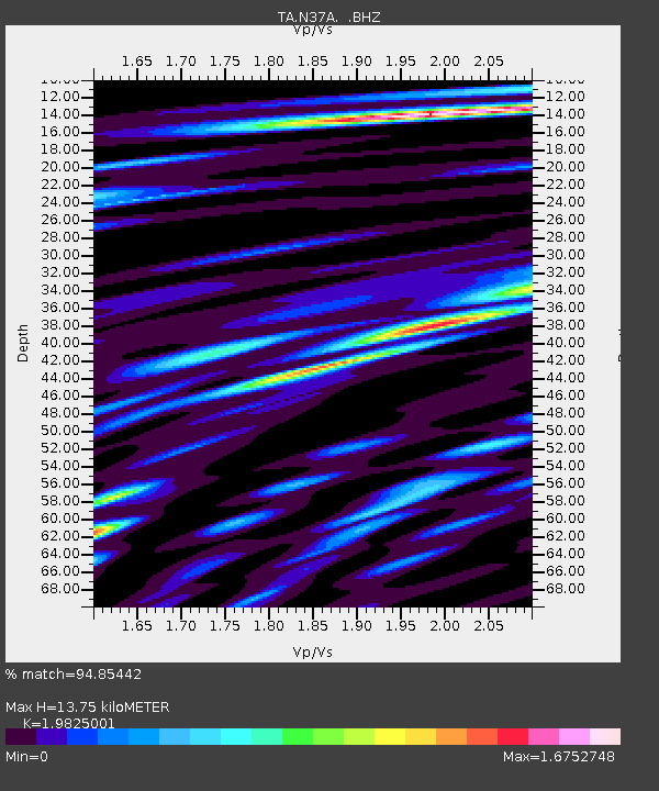
| Estimated Moho Depth: |
13.75 km |
| Estimated Crust Vp/Vs: |
1.98 |
| Assumed Crust Vp: |
6.498 km/s |
| Estimated Crust Vs: |
3.277 km/s |
| Estimated Crust Poisson's Ratio: |
0.33 |
|
| Radial Match: |
94.85442 % |
| Radial Bump: |
400 |
| Transverse Match: |
81.5169 % |
| Transverse Bump: |
400 |
| SOD ConfigId: |
395004 |
| Insert Time: |
2011-12-08 06:07:35.746 +0000 |
| GWidth: |
2.5 |
| Max Bumps: |
400 |
| Tol: |
0.001 |
|

Signal To Noise
| Channel | StoN | STA | LTA |
| TA:N37A: :BHZ:20110628T06:57:09.575002Z | 14.572456 | 9.712198E-7 | 6.6647644E-8 |
| TA:N37A: :BHN:20110628T06:57:09.575002Z | 8.125289 | 5.3897793E-7 | 6.6333385E-8 |
| TA:N37A: :BHE:20110628T06:57:09.575002Z | 6.8921266 | 5.947831E-7 | 8.6298925E-8 |
| Arrivals |
| Ps | 2.2 SECOND |
| PpPs | 6.0 SECOND |
| PsPs/PpSs | 8.2 SECOND |


