You are here: Home > Network List > G - GEOSCOPE Stations List
> Station CAN Canberra, Australia > Earthquake Result Viewer
CAN Canberra, Australia - Earthquake Result Viewer
| Earthquake location: |
Banda Sea |
| Earthquake latitude/longitude: |
-4.1/123.9 |
| Earthquake time(UTC): |
2001/10/19 (292) 03:28:44 GMT |
| Earthquake Depth: |
33 km |
| Earthquake Magnitude: |
6.3 MB, 7.3 MS, 7.5 MW, 7.4 MW |
| Earthquake Catalog/Contributor: |
WHDF/NEIC |
|
| Network: |
G GEOSCOPE |
| Station: |
CAN Canberra, Australia |
| Lat/Lon: |
35.32 S/149.00 E |
| Elevation: |
650 m |
|
| Distance: |
38.8 deg |
| Az: |
146.377 deg |
| Baz: |
317.513 deg |
| Ray Param: |
0.07530323 |
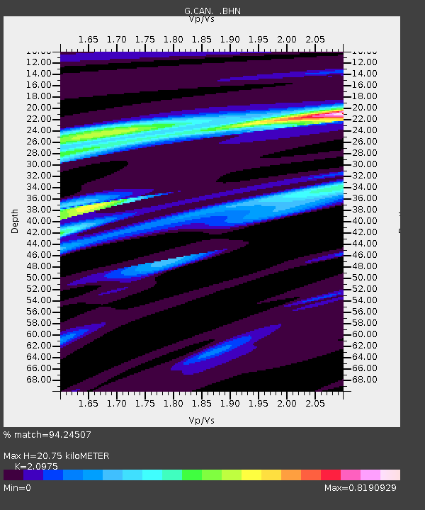
| Estimated Moho Depth: |
20.75 km |
| Estimated Crust Vp/Vs: |
2.10 |
| Assumed Crust Vp: |
6.633 km/s |
| Estimated Crust Vs: |
3.162 km/s |
| Estimated Crust Poisson's Ratio: |
0.35 |
|
| Radial Match: |
94.24507 % |
| Radial Bump: |
314 |
| Transverse Match: |
86.13549 % |
| Transverse Bump: |
400 |
| SOD ConfigId: |
20082 |
| Insert Time: |
2010-02-26 21:34:19.925 +0000 |
| GWidth: |
2.5 |
| Max Bumps: |
400 |
| Tol: |
0.001 |
|

Signal To Noise
| Channel | StoN | STA | LTA |
| G:CAN: :BHN:20011019T03:35:35.42701Z | 8.797208 | 9.569127E-6 | 1.087746E-6 |
| G:CAN: :BHE:20011019T03:35:35.42701Z | 11.008156 | 8.166828E-6 | 7.418888E-7 |
| G:CAN: :BHZ:20011019T03:35:35.42701Z | 10.492726 | 1.9491048E-5 | 1.8575772E-6 |
| Arrivals |
| Ps | 3.7 SECOND |
| PpPs | 9.1 SECOND |
| PsPs/PpSs | 13 SECOND |


