You are here: Home > Network List > TA - USArray Transportable Network (new EarthScope stations) Stations List
> Station X44A Crenshaw, MS, USA > Earthquake Result Viewer
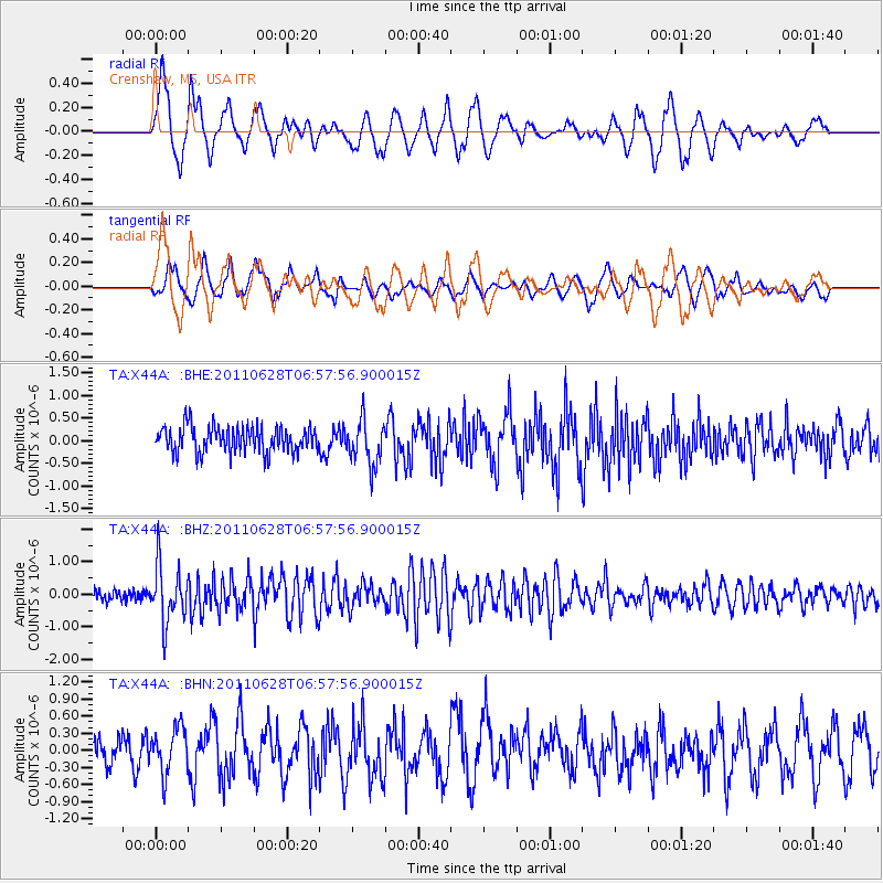
X44A Crenshaw, MS, USA - Earthquake Result Viewer
*The percent match for this event was below the threshold and hence no stack was calculated.
| Earthquake location: |
Fox Islands, Aleutian Islands |
| Earthquake latitude/longitude: |
52.1/-171.7 |
| Earthquake time(UTC): |
2011/06/28 (179) 06:48:32 GMT |
| Earthquake Depth: |
30 km |
| Earthquake Magnitude: |
5.6 MB, 5.4 MS, 5.9 MW, 5.6 MW |
| Earthquake Catalog/Contributor: |
WHDF/NEIC |
|
| Network: |
TA USArray Transportable Network (new EarthScope stations) |
| Station: |
X44A Crenshaw, MS, USA |
| Lat/Lon: |
34.50 N/90.15 W |
| Elevation: |
109 m |
|
| Distance: |
58.8 deg |
| Az: |
72.828 deg |
| Baz: |
314.455 deg |
| Ray Param: |
$rayparam |
*The percent match for this event was below the threshold and hence was not used in the summary stack. |
|
| Radial Match: |
68.25486 % |
| Radial Bump: |
356 |
| Transverse Match: |
67.51357 % |
| Transverse Bump: |
400 |
| SOD ConfigId: |
395004 |
| Insert Time: |
2011-12-08 06:15:31.976 +0000 |
| GWidth: |
2.5 |
| Max Bumps: |
400 |
| Tol: |
0.001 |
|
Signal To Noise
| Channel | StoN | STA | LTA |
| TA:X44A: :BHZ:20110628T06:57:56.900015Z | 5.6572366 | 8.653603E-7 | 1.529652E-7 |
| TA:X44A: :BHN:20110628T06:57:56.900015Z | 1.2486258 | 3.9600687E-7 | 3.1715416E-7 |
| TA:X44A: :BHE:20110628T06:57:56.900015Z | 1.7379386 | 4.987175E-7 | 2.8695922E-7 |
| Arrivals |
| Ps | |
| PpPs | |
| PsPs/PpSs | |


