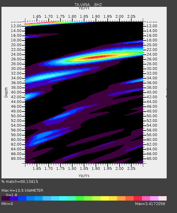
V45A Humboldt, TN, USA - Earthquake Result Viewer

Earthquake location: Fox Islands, Aleutian Islands
Earthquake latitude/longitude: 52.1/-171.7
Earthquake time(UTC): 2011/06/28 (179) 06:48:32 GMT
Earthquake Depth: 30 km
Earthquake Magnitude: 5.6 MB, 5.4 MS, 5.9 MW, 5.6 MW
Earthquake Catalog/Contributor: WHDF/NEIC
Network: TA USArray Transportable Network (new EarthScope stations)
Station: V45A Humboldt, TN, USA
Lat/Lon: 35.74 N/88.96 W
Elevation: 126 m
Distance: 58.6 deg
Az: 70.995 deg
Baz: 314.183 deg
Ray Param: 0.06269061
Estimated Moho Depth: 10.5 km
Estimated Crust Vp/Vs: 1.60
Assumed Crust Vp: 6.38 km/s
Estimated Crust Vs: 3.988 km/s
Estimated Crust Poisson's Ratio: 0.18
Radial Match: 88.10615 %
Radial Bump: 400
Transverse Match: 64.65762 %
Transverse Bump: 400
SOD ConfigId: 395004
Insert Time: 2011-12-08 06:15:49.661 +0000
GWidth: 2.5
Max Bumps: 400
Tol: 0.001

Signal To Noise

ChannelStoNSTALTA
TA:V45A: :BHZ:20110628T06:57:55.725027Z6.9572667.601959E-71.0926647E-7
TA:V45A: :BHN:20110628T06:57:55.725027Z2.754396.9090976E-72.508395E-7
TA:V45A: :BHE:20110628T06:57:55.725027Z2.58985885.790308E-72.2357622E-7
Arrivals
Ps1.0 SECOND
PpPs4.1 SECOND
PsPs/PpSs5.1 SECOND