You are here: Home > Network List > TA - USArray Transportable Network (new EarthScope stations) Stations List
> Station S43A Fulton Ridge, Patton, MO, USA > Earthquake Result Viewer
S43A Fulton Ridge, Patton, MO, USA - Earthquake Result Viewer
| Earthquake location: |
Fox Islands, Aleutian Islands |
| Earthquake latitude/longitude: |
52.1/-171.7 |
| Earthquake time(UTC): |
2011/06/28 (179) 06:48:32 GMT |
| Earthquake Depth: |
30 km |
| Earthquake Magnitude: |
5.6 MB, 5.4 MS, 5.9 MW, 5.6 MW |
| Earthquake Catalog/Contributor: |
WHDF/NEIC |
|
| Network: |
TA USArray Transportable Network (new EarthScope stations) |
| Station: |
S43A Fulton Ridge, Patton, MO, USA |
| Lat/Lon: |
37.57 N/90.08 W |
| Elevation: |
263 m |
|
| Distance: |
56.7 deg |
| Az: |
70.162 deg |
| Baz: |
313.073 deg |
| Ray Param: |
0.06392791 |
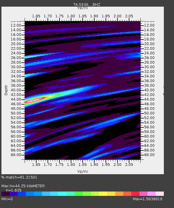
| Estimated Moho Depth: |
44.25 km |
| Estimated Crust Vp/Vs: |
1.63 |
| Assumed Crust Vp: |
6.53 km/s |
| Estimated Crust Vs: |
3.994 km/s |
| Estimated Crust Poisson's Ratio: |
0.20 |
|
| Radial Match: |
91.21501 % |
| Radial Bump: |
321 |
| Transverse Match: |
61.21092 % |
| Transverse Bump: |
400 |
| SOD ConfigId: |
395004 |
| Insert Time: |
2011-12-08 06:16:33.417 +0000 |
| GWidth: |
2.5 |
| Max Bumps: |
400 |
| Tol: |
0.001 |
|

Signal To Noise
| Channel | StoN | STA | LTA |
| TA:S43A: :BHZ:20110628T06:57:42.325002Z | 15.950289 | 4.8466893E-7 | 3.0386214E-8 |
| TA:S43A: :BHN:20110628T06:57:42.325002Z | 5.755242 | 3.3359305E-7 | 5.7963337E-8 |
| TA:S43A: :BHE:20110628T06:57:42.325002Z | 6.5550346 | 3.709783E-7 | 5.6594406E-8 |
| Arrivals |
| Ps | 4.6 SECOND |
| PpPs | 17 SECOND |
| PsPs/PpSs | 21 SECOND |


