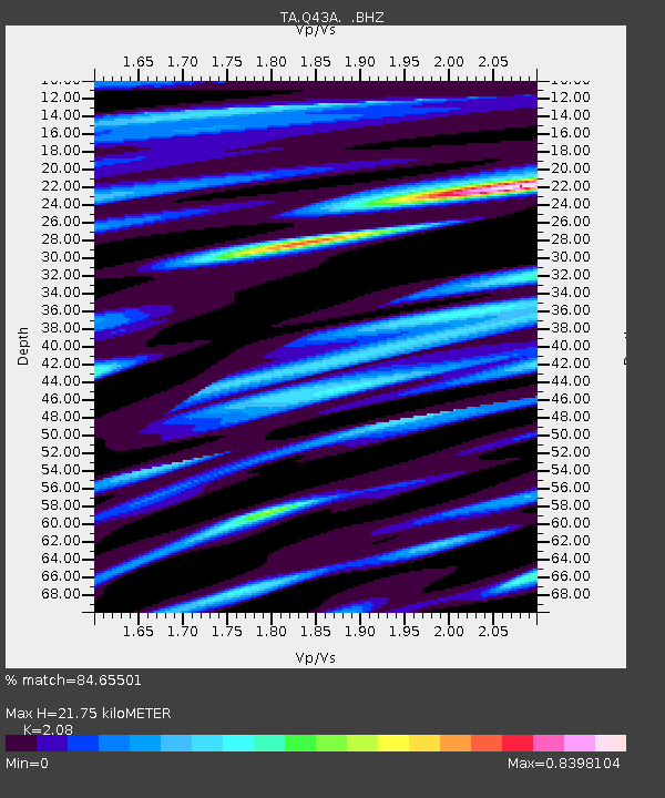
Q43A New Douglas, IL, USA - Earthquake Result Viewer
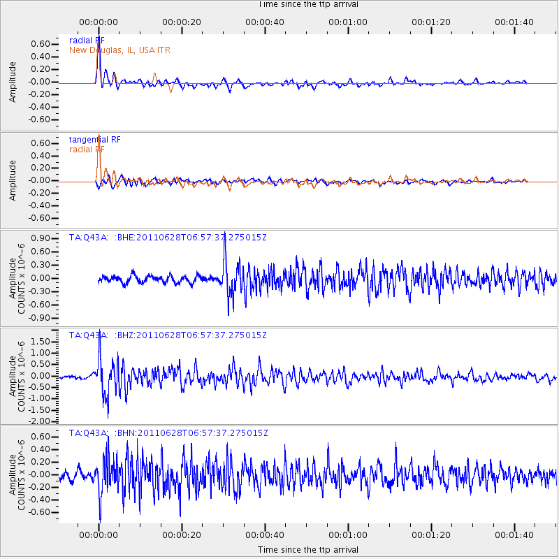
Earthquake location: Fox Islands, Aleutian Islands
Earthquake latitude/longitude: 52.1/-171.7
Earthquake time(UTC): 2011/06/28 (179) 06:48:32 GMT
Earthquake Depth: 30 km
Earthquake Magnitude: 5.6 MB, 5.4 MS, 5.9 MW, 5.6 MW
Earthquake Catalog/Contributor: WHDF/NEIC
Network: TA USArray Transportable Network (new EarthScope stations)
Station: Q43A New Douglas, IL, USA
Lat/Lon: 38.94 N/89.70 W
Elevation: 202 m
Distance: 56.0 deg
Az: 68.715 deg
Baz: 312.503 deg
Ray Param: 0.064391926
Estimated Moho Depth: 21.75 km
Estimated Crust Vp/Vs: 2.08
Assumed Crust Vp: 6.444 km/s
Estimated Crust Vs: 3.098 km/s
Estimated Crust Poisson's Ratio: 0.35
Radial Match: 84.65501 %
Radial Bump: 393
Transverse Match: 73.58713 %
Transverse Bump: 400
SOD ConfigId: 395004
Insert Time: 2011-12-08 06:17:23.705 +0000
GWidth: 2.5
Max Bumps: 400
Tol: 0.001

Signal To Noise

ChannelStoNSTALTA
TA:Q43A: :BHZ:20110628T06:57:37.275015Z17.9892088.252004E-74.587197E-8
TA:Q43A: :BHN:20110628T06:57:37.275015Z4.05691052.7947354E-76.888827E-8
TA:Q43A: :BHE:20110628T06:57:37.275015Z5.13097053.8817598E-77.565352E-8
Arrivals
Ps3.8 SECOND
PpPs10.0 SECOND
PsPs/PpSs14 SECOND