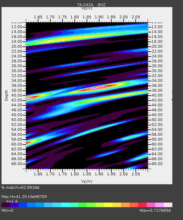
O42A Bath, IL, USA - Earthquake Result Viewer
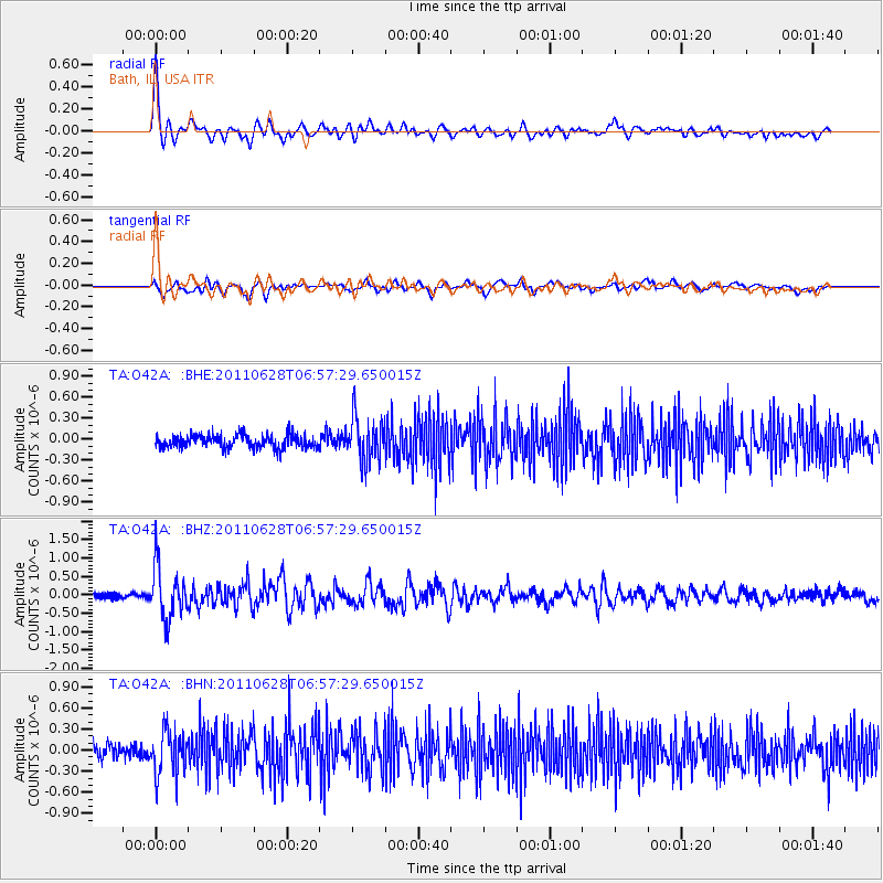
Earthquake location: Fox Islands, Aleutian Islands
Earthquake latitude/longitude: 52.1/-171.7
Earthquake time(UTC): 2011/06/28 (179) 06:48:32 GMT
Earthquake Depth: 30 km
Earthquake Magnitude: 5.6 MB, 5.4 MS, 5.9 MW, 5.6 MW
Earthquake Catalog/Contributor: WHDF/NEIC
Network: TA USArray Transportable Network (new EarthScope stations)
Station: O42A Bath, IL, USA
Lat/Lon: 40.20 N/90.08 W
Elevation: 155 m
Distance: 54.9 deg
Az: 67.827 deg
Baz: 311.757 deg
Ray Param: 0.06508698
Estimated Moho Depth: 41.25 km
Estimated Crust Vp/Vs: 1.60
Assumed Crust Vp: 6.498 km/s
Estimated Crust Vs: 4.061 km/s
Estimated Crust Poisson's Ratio: 0.18
Radial Match: 82.99366 %
Radial Bump: 400
Transverse Match: 65.033646 %
Transverse Bump: 400
SOD ConfigId: 395004
Insert Time: 2011-12-08 06:18:03.988 +0000
GWidth: 2.5
Max Bumps: 400
Tol: 0.001

Signal To Noise

ChannelStoNSTALTA
TA:O42A: :BHZ:20110628T06:57:29.650015Z8.7189257.030998E-78.0640646E-8
TA:O42A: :BHN:20110628T06:57:29.650015Z3.07636263.1154622E-71.0127097E-7
TA:O42A: :BHE:20110628T06:57:29.650015Z3.34446293.1559293E-79.436281E-8
Arrivals
Ps4.0 SECOND
PpPs16 SECOND
PsPs/PpSs20 SECOND