You are here: Home > Network List > BK - Berkeley Digital Seismograph Network Stations List
> Station SAO San Andreas Geophysical Obs., Hollister, CA, USA > Earthquake Result Viewer
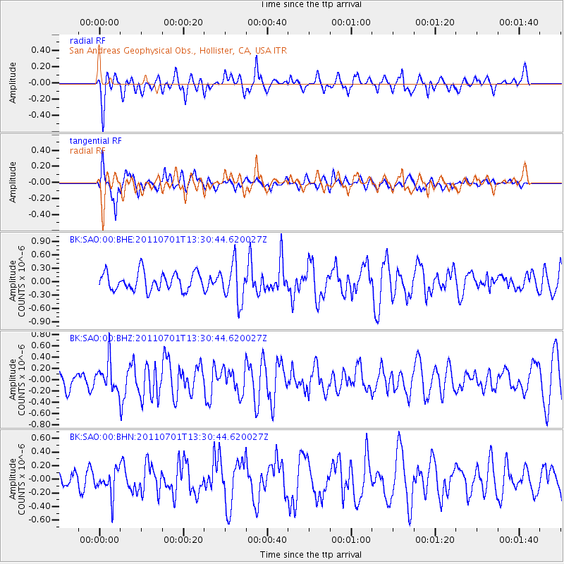
SAO San Andreas Geophysical Obs., Hollister, CA, USA - Earthquake Result Viewer
*The percent match for this event was below the threshold and hence no stack was calculated.
| Earthquake location: |
South Of Mariana Islands |
| Earthquake latitude/longitude: |
13.1/146.6 |
| Earthquake time(UTC): |
2011/07/01 (182) 13:18:50 GMT |
| Earthquake Depth: |
39 km |
| Earthquake Magnitude: |
5.9 MB, 5.2 MS, 5.6 MW, 5.5 MW |
| Earthquake Catalog/Contributor: |
WHDF/NEIC |
|
| Network: |
BK Berkeley Digital Seismograph Network |
| Station: |
SAO San Andreas Geophysical Obs., Hollister, CA, USA |
| Lat/Lon: |
36.76 N/121.45 W |
| Elevation: |
317 m |
|
| Distance: |
83.8 deg |
| Az: |
53.823 deg |
| Baz: |
281.679 deg |
| Ray Param: |
$rayparam |
*The percent match for this event was below the threshold and hence was not used in the summary stack. |
|
| Radial Match: |
54.989605 % |
| Radial Bump: |
400 |
| Transverse Match: |
58.56423 % |
| Transverse Bump: |
400 |
| SOD ConfigId: |
395004 |
| Insert Time: |
2011-12-08 06:40:36.486 +0000 |
| GWidth: |
2.5 |
| Max Bumps: |
400 |
| Tol: |
0.001 |
|
Signal To Noise
| Channel | StoN | STA | LTA |
| BK:SAO:00:BHZ:20110701T13:30:44.620027Z | 1.6374873 | 2.6933557E-7 | 1.6448101E-7 |
| BK:SAO:00:BHN:20110701T13:30:44.620027Z | 1.0392308 | 1.9489754E-7 | 1.8754018E-7 |
| BK:SAO:00:BHE:20110701T13:30:44.620027Z | 2.2257648 | 4.4004693E-7 | 1.9770594E-7 |
| Arrivals |
| Ps | |
| PpPs | |
| PsPs/PpSs | |


