You are here: Home > Network List > CI - Caltech Regional Seismic Network Stations List
> Station SMM Simmler, CA, USA > Earthquake Result Viewer
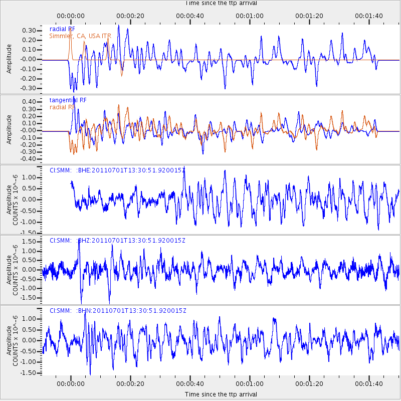
SMM Simmler, CA, USA - Earthquake Result Viewer
*The percent match for this event was below the threshold and hence no stack was calculated.
| Earthquake location: |
South Of Mariana Islands |
| Earthquake latitude/longitude: |
13.1/146.6 |
| Earthquake time(UTC): |
2011/07/01 (182) 13:18:50 GMT |
| Earthquake Depth: |
39 km |
| Earthquake Magnitude: |
5.9 MB, 5.2 MS, 5.6 MW, 5.5 MW |
| Earthquake Catalog/Contributor: |
WHDF/NEIC |
|
| Network: |
CI Caltech Regional Seismic Network |
| Station: |
SMM Simmler, CA, USA |
| Lat/Lon: |
35.31 N/120.00 W |
| Elevation: |
599 m |
|
| Distance: |
85.3 deg |
| Az: |
54.994 deg |
| Baz: |
282.64 deg |
| Ray Param: |
$rayparam |
*The percent match for this event was below the threshold and hence was not used in the summary stack. |
|
| Radial Match: |
50.71517 % |
| Radial Bump: |
400 |
| Transverse Match: |
37.38119 % |
| Transverse Bump: |
400 |
| SOD ConfigId: |
395004 |
| Insert Time: |
2011-12-08 06:42:56.876 +0000 |
| GWidth: |
2.5 |
| Max Bumps: |
400 |
| Tol: |
0.001 |
|
Signal To Noise
| Channel | StoN | STA | LTA |
| CI:SMM: :BHZ:20110701T13:30:51.920015Z | 2.450629 | 7.0462346E-7 | 2.8752763E-7 |
| CI:SMM: :BHN:20110701T13:30:51.920015Z | 1.0234301 | 3.8785416E-7 | 3.7897476E-7 |
| CI:SMM: :BHE:20110701T13:30:51.920015Z | 0.88240224 | 2.7102786E-7 | 3.0714776E-7 |
| Arrivals |
| Ps | |
| PpPs | |
| PsPs/PpSs | |


