You are here: Home > Network List > CI - Caltech Regional Seismic Network Stations List
> Station MUR Murrieta > Earthquake Result Viewer
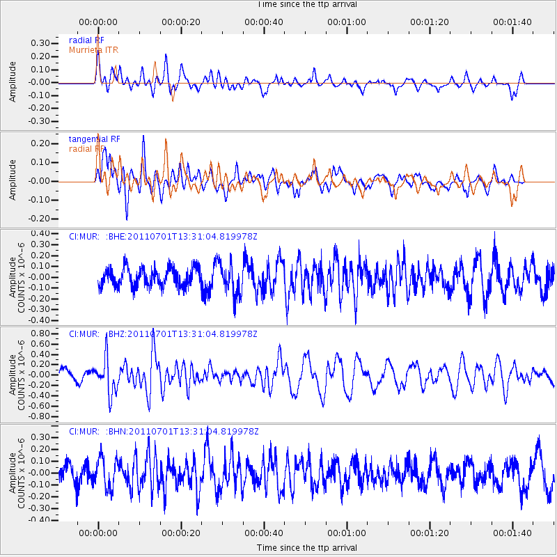
MUR Murrieta - Earthquake Result Viewer
*The percent match for this event was below the threshold and hence no stack was calculated.
| Earthquake location: |
South Of Mariana Islands |
| Earthquake latitude/longitude: |
13.1/146.6 |
| Earthquake time(UTC): |
2011/07/01 (182) 13:18:50 GMT |
| Earthquake Depth: |
39 km |
| Earthquake Magnitude: |
5.9 MB, 5.2 MS, 5.6 MW, 5.5 MW |
| Earthquake Catalog/Contributor: |
WHDF/NEIC |
|
| Network: |
CI Caltech Regional Seismic Network |
| Station: |
MUR Murrieta |
| Lat/Lon: |
33.60 N/117.20 W |
| Elevation: |
562 m |
|
| Distance: |
87.9 deg |
| Az: |
56.12 deg |
| Baz: |
284.284 deg |
| Ray Param: |
$rayparam |
*The percent match for this event was below the threshold and hence was not used in the summary stack. |
|
| Radial Match: |
63.417767 % |
| Radial Bump: |
400 |
| Transverse Match: |
56.39162 % |
| Transverse Bump: |
400 |
| SOD ConfigId: |
395004 |
| Insert Time: |
2011-12-08 06:44:53.555 +0000 |
| GWidth: |
2.5 |
| Max Bumps: |
400 |
| Tol: |
0.001 |
|
Signal To Noise
| Channel | StoN | STA | LTA |
| CI:MUR: :BHZ:20110701T13:31:04.819978Z | 1.805193 | 3.4627223E-7 | 1.9182005E-7 |
| CI:MUR: :BHN:20110701T13:31:04.819978Z | 1.1797912 | 1.2693779E-7 | 1.07593436E-7 |
| CI:MUR: :BHE:20110701T13:31:04.819978Z | 1.7272228 | 1.434657E-7 | 8.3061494E-8 |
| Arrivals |
| Ps | |
| PpPs | |
| PsPs/PpSs | |


