You are here: Home > Network List > TA - USArray Transportable Network (new EarthScope stations) Stations List
> Station M04C Macdoel, CA, USA > Earthquake Result Viewer
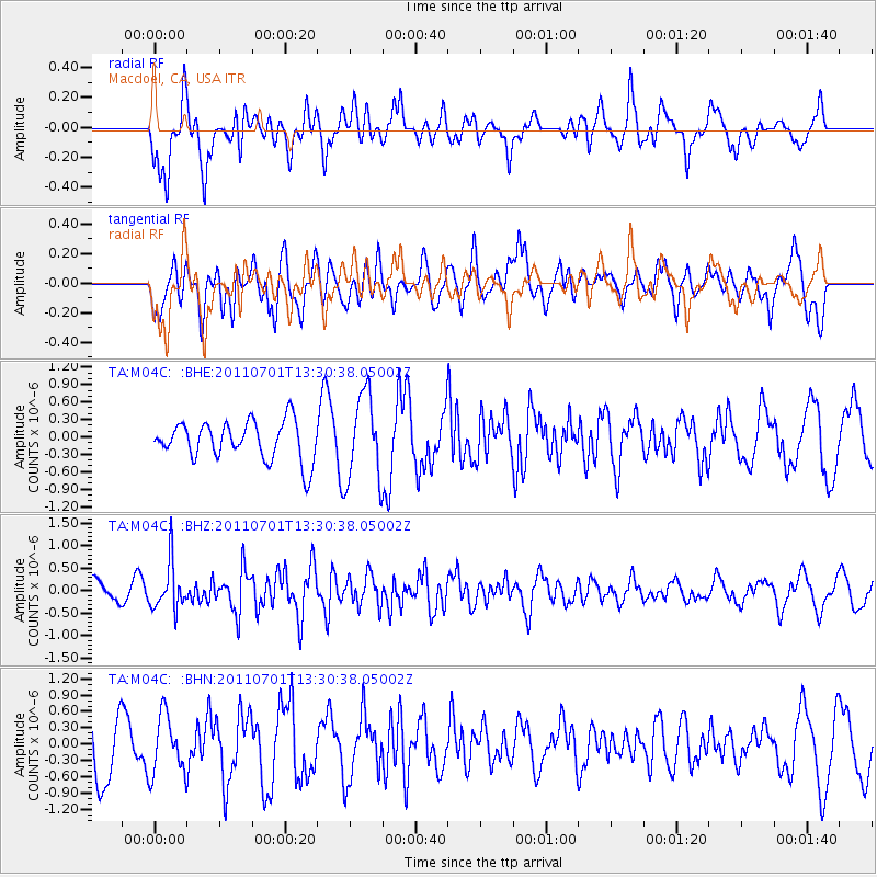
M04C Macdoel, CA, USA - Earthquake Result Viewer
*The percent match for this event was below the threshold and hence no stack was calculated.
| Earthquake location: |
South Of Mariana Islands |
| Earthquake latitude/longitude: |
13.1/146.6 |
| Earthquake time(UTC): |
2011/07/01 (182) 13:18:50 GMT |
| Earthquake Depth: |
39 km |
| Earthquake Magnitude: |
5.9 MB, 5.2 MS, 5.6 MW, 5.5 MW |
| Earthquake Catalog/Contributor: |
WHDF/NEIC |
|
| Network: |
TA USArray Transportable Network (new EarthScope stations) |
| Station: |
M04C Macdoel, CA, USA |
| Lat/Lon: |
41.78 N/121.84 W |
| Elevation: |
1391 m |
|
| Distance: |
82.6 deg |
| Az: |
48.933 deg |
| Baz: |
280.853 deg |
| Ray Param: |
$rayparam |
*The percent match for this event was below the threshold and hence was not used in the summary stack. |
|
| Radial Match: |
74.793045 % |
| Radial Bump: |
400 |
| Transverse Match: |
56.251427 % |
| Transverse Bump: |
400 |
| SOD ConfigId: |
395004 |
| Insert Time: |
2011-12-08 06:52:38.835 +0000 |
| GWidth: |
2.5 |
| Max Bumps: |
400 |
| Tol: |
0.001 |
|
Signal To Noise
| Channel | StoN | STA | LTA |
| TA:M04C: :BHZ:20110701T13:30:38.05002Z | 2.17117 | 5.1838674E-7 | 2.3875918E-7 |
| TA:M04C: :BHN:20110701T13:30:38.05002Z | 0.8900247 | 5.4380035E-7 | 6.109947E-7 |
| TA:M04C: :BHE:20110701T13:30:38.05002Z | 2.2319636 | 7.440854E-7 | 3.3337705E-7 |
| Arrivals |
| Ps | |
| PpPs | |
| PsPs/PpSs | |


