You are here: Home > Network List > TA - USArray Transportable Network (new EarthScope stations) Stations List
> Station L04D Klamath Falls, OR, USA > Earthquake Result Viewer
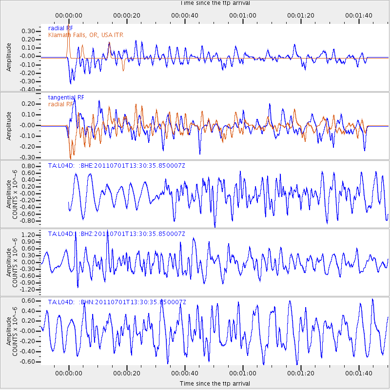
L04D Klamath Falls, OR, USA - Earthquake Result Viewer
*The percent match for this event was below the threshold and hence no stack was calculated.
| Earthquake location: |
South Of Mariana Islands |
| Earthquake latitude/longitude: |
13.1/146.6 |
| Earthquake time(UTC): |
2011/07/01 (182) 13:18:50 GMT |
| Earthquake Depth: |
39 km |
| Earthquake Magnitude: |
5.9 MB, 5.2 MS, 5.6 MW, 5.5 MW |
| Earthquake Catalog/Contributor: |
WHDF/NEIC |
|
| Network: |
TA USArray Transportable Network (new EarthScope stations) |
| Station: |
L04D Klamath Falls, OR, USA |
| Lat/Lon: |
42.22 N/122.30 W |
| Elevation: |
1437 m |
|
| Distance: |
82.1 deg |
| Az: |
48.566 deg |
| Baz: |
280.494 deg |
| Ray Param: |
$rayparam |
*The percent match for this event was below the threshold and hence was not used in the summary stack. |
|
| Radial Match: |
45.20672 % |
| Radial Bump: |
400 |
| Transverse Match: |
58.064304 % |
| Transverse Bump: |
400 |
| SOD ConfigId: |
395004 |
| Insert Time: |
2011-12-08 06:55:18.486 +0000 |
| GWidth: |
2.5 |
| Max Bumps: |
400 |
| Tol: |
0.001 |
|
Signal To Noise
| Channel | StoN | STA | LTA |
| TA:L04D: :BHZ:20110701T13:30:35.850007Z | 1.8343314 | 5.2941954E-7 | 2.8861717E-7 |
| TA:L04D: :BHN:20110701T13:30:35.850007Z | 0.7311779 | 2.4504453E-7 | 3.3513666E-7 |
| TA:L04D: :BHE:20110701T13:30:35.850007Z | 0.538239 | 1.7283782E-7 | 3.2111723E-7 |
| Arrivals |
| Ps | |
| PpPs | |
| PsPs/PpSs | |


