You are here: Home > Network List > TA - USArray Transportable Network (new EarthScope stations) Stations List
> Station O03D Paynes Creek, CA, USA > Earthquake Result Viewer
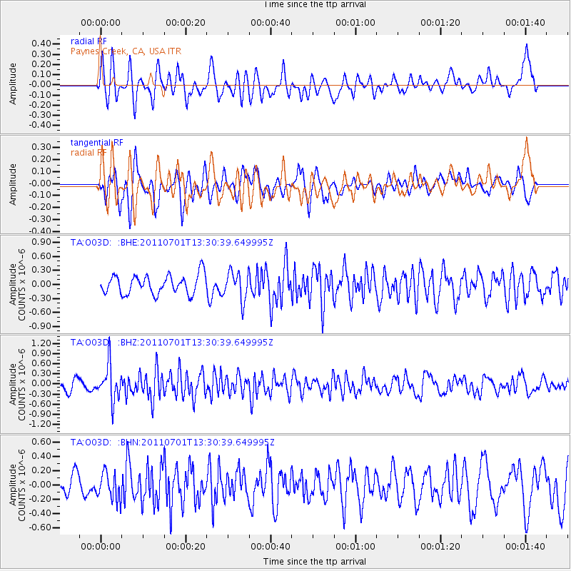
O03D Paynes Creek, CA, USA - Earthquake Result Viewer
*The percent match for this event was below the threshold and hence no stack was calculated.
| Earthquake location: |
South Of Mariana Islands |
| Earthquake latitude/longitude: |
13.1/146.6 |
| Earthquake time(UTC): |
2011/07/01 (182) 13:18:50 GMT |
| Earthquake Depth: |
39 km |
| Earthquake Magnitude: |
5.9 MB, 5.2 MS, 5.6 MW, 5.5 MW |
| Earthquake Catalog/Contributor: |
WHDF/NEIC |
|
| Network: |
TA USArray Transportable Network (new EarthScope stations) |
| Station: |
O03D Paynes Creek, CA, USA |
| Lat/Lon: |
40.29 N/121.80 W |
| Elevation: |
968 m |
|
| Distance: |
82.9 deg |
| Az: |
50.399 deg |
| Baz: |
281.063 deg |
| Ray Param: |
$rayparam |
*The percent match for this event was below the threshold and hence was not used in the summary stack. |
|
| Radial Match: |
62.868908 % |
| Radial Bump: |
400 |
| Transverse Match: |
64.09487 % |
| Transverse Bump: |
400 |
| SOD ConfigId: |
395004 |
| Insert Time: |
2011-12-08 06:55:31.451 +0000 |
| GWidth: |
2.5 |
| Max Bumps: |
400 |
| Tol: |
0.001 |
|
Signal To Noise
| Channel | StoN | STA | LTA |
| TA:O03D: :BHZ:20110701T13:30:39.649995Z | 3.256121 | 5.2924156E-7 | 1.6253743E-7 |
| TA:O03D: :BHN:20110701T13:30:39.649995Z | 1.7405058 | 1.9047178E-7 | 1.0943473E-7 |
| TA:O03D: :BHE:20110701T13:30:39.649995Z | 1.5339963 | 3.0935598E-7 | 2.0166671E-7 |
| Arrivals |
| Ps | |
| PpPs | |
| PsPs/PpSs | |


