You are here: Home > Network List > UW - Pacific Northwest Regional Seismic Network Stations List
> Station WOLL Wollman Farm, Schrag, WA, USA > Earthquake Result Viewer
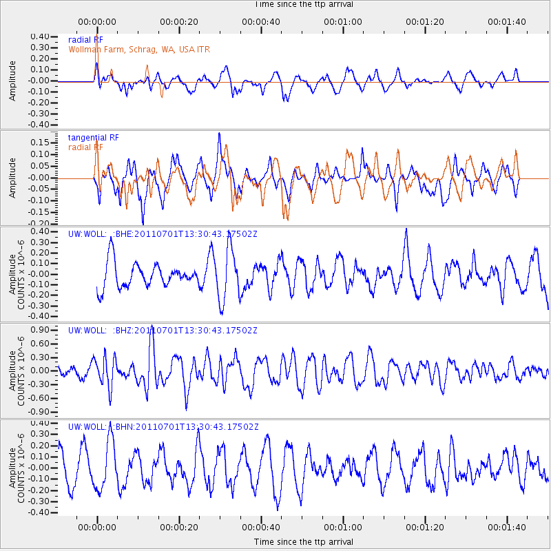
WOLL Wollman Farm, Schrag, WA, USA - Earthquake Result Viewer
*The percent match for this event was below the threshold and hence no stack was calculated.
| Earthquake location: |
South Of Mariana Islands |
| Earthquake latitude/longitude: |
13.1/146.6 |
| Earthquake time(UTC): |
2011/07/01 (182) 13:18:50 GMT |
| Earthquake Depth: |
39 km |
| Earthquake Magnitude: |
5.9 MB, 5.2 MS, 5.6 MW, 5.5 MW |
| Earthquake Catalog/Contributor: |
WHDF/NEIC |
|
| Network: |
UW Pacific Northwest Regional Seismic Network |
| Station: |
WOLL Wollman Farm, Schrag, WA, USA |
| Lat/Lon: |
47.06 N/118.92 W |
| Elevation: |
385 m |
|
| Distance: |
83.6 deg |
| Az: |
43.307 deg |
| Baz: |
282.211 deg |
| Ray Param: |
$rayparam |
*The percent match for this event was below the threshold and hence was not used in the summary stack. |
|
| Radial Match: |
59.78318 % |
| Radial Bump: |
400 |
| Transverse Match: |
41.516373 % |
| Transverse Bump: |
400 |
| SOD ConfigId: |
395004 |
| Insert Time: |
2011-12-08 06:58:02.047 +0000 |
| GWidth: |
2.5 |
| Max Bumps: |
400 |
| Tol: |
0.001 |
|
Signal To Noise
| Channel | StoN | STA | LTA |
| UW:WOLL: :BHZ:20110701T13:30:43.17502Z | 2.8938267 | 3.284837E-7 | 1.1351188E-7 |
| UW:WOLL: :BHN:20110701T13:30:43.17502Z | 1.7060252 | 2.214325E-7 | 1.2979439E-7 |
| UW:WOLL: :BHE:20110701T13:30:43.17502Z | 2.1578147 | 2.493733E-7 | 1.1556752E-7 |
| Arrivals |
| Ps | |
| PpPs | |
| PsPs/PpSs | |


