You are here: Home > Network List > CI - Caltech Regional Seismic Network Stations List
> Station SWS Sam W. Stewart, Westmorland, CA, USA > Earthquake Result Viewer
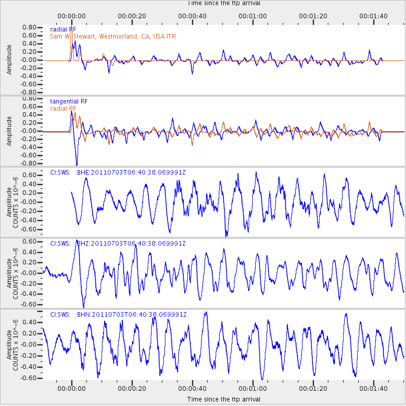
SWS Sam W. Stewart, Westmorland, CA, USA - Earthquake Result Viewer
*The percent match for this event was below the threshold and hence no stack was calculated.
| Earthquake location: |
Near Coast Of Nicaragua |
| Earthquake latitude/longitude: |
12.4/-87.6 |
| Earthquake time(UTC): |
2011/07/03 (184) 06:34:39 GMT |
| Earthquake Depth: |
59 km |
| Earthquake Magnitude: |
5.5 MB, 5.8 MW, 5.7 MW |
| Earthquake Catalog/Contributor: |
WHDF/NEIC |
|
| Network: |
CI Caltech Regional Seismic Network |
| Station: |
SWS Sam W. Stewart, Westmorland, CA, USA |
| Lat/Lon: |
32.94 N/115.80 W |
| Elevation: |
140 m |
|
| Distance: |
32.9 deg |
| Az: |
312.985 deg |
| Baz: |
121.8 deg |
| Ray Param: |
$rayparam |
*The percent match for this event was below the threshold and hence was not used in the summary stack. |
|
| Radial Match: |
67.86785 % |
| Radial Bump: |
377 |
| Transverse Match: |
71.31797 % |
| Transverse Bump: |
345 |
| SOD ConfigId: |
395004 |
| Insert Time: |
2011-12-10 04:47:29.332 +0000 |
| GWidth: |
2.5 |
| Max Bumps: |
400 |
| Tol: |
0.001 |
|
Signal To Noise
| Channel | StoN | STA | LTA |
| CI:SWS: :BHZ:20110703T06:40:38.069991Z | 2.0474122 | 3.9819582E-7 | 1.9448737E-7 |
| CI:SWS: :BHN:20110703T06:40:38.069991Z | 1.0475991 | 1.9762336E-7 | 1.8864407E-7 |
| CI:SWS: :BHE:20110703T06:40:38.069991Z | 1.4739839 | 3.6081042E-7 | 2.4478584E-7 |
| Arrivals |
| Ps | |
| PpPs | |
| PsPs/PpSs | |


