You are here: Home > Network List > NE - New England Seismic Network Stations List
> Station FFD Franklin Falls Dam, NH > Earthquake Result Viewer
FFD Franklin Falls Dam, NH - Earthquake Result Viewer
| Earthquake location: |
Near Coast Of Nicaragua |
| Earthquake latitude/longitude: |
12.4/-87.6 |
| Earthquake time(UTC): |
2011/07/03 (184) 06:34:39 GMT |
| Earthquake Depth: |
59 km |
| Earthquake Magnitude: |
5.5 MB, 5.8 MW, 5.7 MW |
| Earthquake Catalog/Contributor: |
WHDF/NEIC |
|
| Network: |
NE New England Seismic Network |
| Station: |
FFD Franklin Falls Dam, NH |
| Lat/Lon: |
43.47 N/71.65 W |
| Elevation: |
131 m |
|
| Distance: |
33.9 deg |
| Az: |
21.012 deg |
| Baz: |
208.76 deg |
| Ray Param: |
0.07786993 |
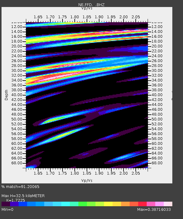
| Estimated Moho Depth: |
32.5 km |
| Estimated Crust Vp/Vs: |
1.72 |
| Assumed Crust Vp: |
6.419 km/s |
| Estimated Crust Vs: |
3.727 km/s |
| Estimated Crust Poisson's Ratio: |
0.25 |
|
| Radial Match: |
91.20065 % |
| Radial Bump: |
357 |
| Transverse Match: |
63.030293 % |
| Transverse Bump: |
400 |
| SOD ConfigId: |
395004 |
| Insert Time: |
2011-12-10 04:53:10.808 +0000 |
| GWidth: |
2.5 |
| Max Bumps: |
400 |
| Tol: |
0.001 |
|

Signal To Noise
| Channel | StoN | STA | LTA |
| NE:FFD: :BHZ:20110703T06:40:46.294998Z | 4.8039217 | 4.1471273E-7 | 8.632795E-8 |
| NE:FFD: :BHN:20110703T06:40:46.294998Z | 6.759552 | 5.9054173E-7 | 8.736403E-8 |
| NE:FFD: :BHE:20110703T06:40:46.294998Z | 2.8989565 | 1.9251686E-7 | 6.640902E-8 |
| Arrivals |
| Ps | 4.0 SECOND |
| PpPs | 13 SECOND |
| PsPs/PpSs | 17 SECOND |


