You are here: Home > Network List > TA - USArray Transportable Network (new EarthScope stations) Stations List
> Station Y12C Blythe, CA, USA > Earthquake Result Viewer
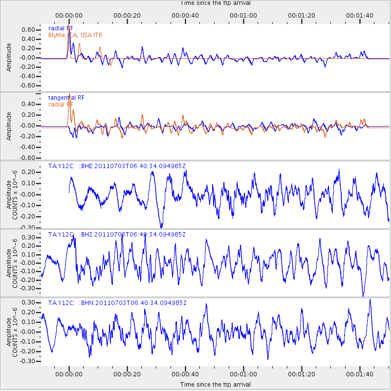
Y12C Blythe, CA, USA - Earthquake Result Viewer
*The percent match for this event was below the threshold and hence no stack was calculated.
| Earthquake location: |
Near Coast Of Nicaragua |
| Earthquake latitude/longitude: |
12.4/-87.6 |
| Earthquake time(UTC): |
2011/07/03 (184) 06:34:39 GMT |
| Earthquake Depth: |
59 km |
| Earthquake Magnitude: |
5.5 MB, 5.8 MW, 5.7 MW |
| Earthquake Catalog/Contributor: |
WHDF/NEIC |
|
| Network: |
TA USArray Transportable Network (new EarthScope stations) |
| Station: |
Y12C Blythe, CA, USA |
| Lat/Lon: |
33.75 N/114.52 W |
| Elevation: |
196 m |
|
| Distance: |
32.5 deg |
| Az: |
315.314 deg |
| Baz: |
124.457 deg |
| Ray Param: |
$rayparam |
*The percent match for this event was below the threshold and hence was not used in the summary stack. |
|
| Radial Match: |
68.93434 % |
| Radial Bump: |
400 |
| Transverse Match: |
64.57981 % |
| Transverse Bump: |
400 |
| SOD ConfigId: |
395004 |
| Insert Time: |
2011-12-10 04:54:07.564 +0000 |
| GWidth: |
2.5 |
| Max Bumps: |
400 |
| Tol: |
0.001 |
|
Signal To Noise
| Channel | StoN | STA | LTA |
| TA:Y12C: :BHZ:20110703T06:40:34.094985Z | 1.7604103 | 1.9074177E-7 | 1.0835075E-7 |
| TA:Y12C: :BHN:20110703T06:40:34.094985Z | 0.6760806 | 5.4495814E-8 | 8.06055E-8 |
| TA:Y12C: :BHE:20110703T06:40:34.094985Z | 2.4067593 | 1.7025638E-7 | 7.074093E-8 |
| Arrivals |
| Ps | |
| PpPs | |
| PsPs/PpSs | |


