You are here: Home > Network List > TA - USArray Transportable Network (new EarthScope stations) Stations List
> Station A27A Ledoux Ranch, Antler, ND, USA > Earthquake Result Viewer
A27A Ledoux Ranch, Antler, ND, USA - Earthquake Result Viewer
| Earthquake location: |
Near Coast Of Nicaragua |
| Earthquake latitude/longitude: |
12.4/-87.6 |
| Earthquake time(UTC): |
2011/07/03 (184) 06:34:39 GMT |
| Earthquake Depth: |
59 km |
| Earthquake Magnitude: |
5.5 MB, 5.8 MW, 5.7 MW |
| Earthquake Catalog/Contributor: |
WHDF/NEIC |
|
| Network: |
TA USArray Transportable Network (new EarthScope stations) |
| Station: |
A27A Ledoux Ranch, Antler, ND, USA |
| Lat/Lon: |
48.95 N/101.24 W |
| Elevation: |
466 m |
|
| Distance: |
38.2 deg |
| Az: |
345.409 deg |
| Baz: |
158.077 deg |
| Ray Param: |
0.07555835 |
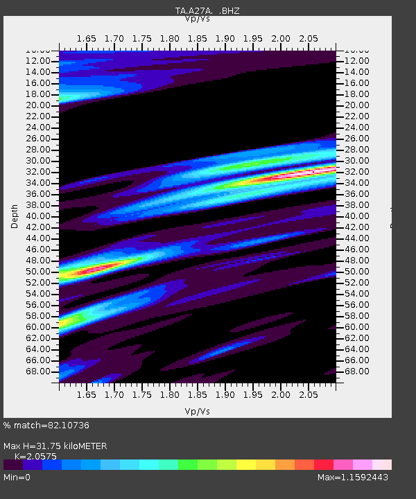
| Estimated Moho Depth: |
31.75 km |
| Estimated Crust Vp/Vs: |
2.06 |
| Assumed Crust Vp: |
6.438 km/s |
| Estimated Crust Vs: |
3.129 km/s |
| Estimated Crust Poisson's Ratio: |
0.35 |
|
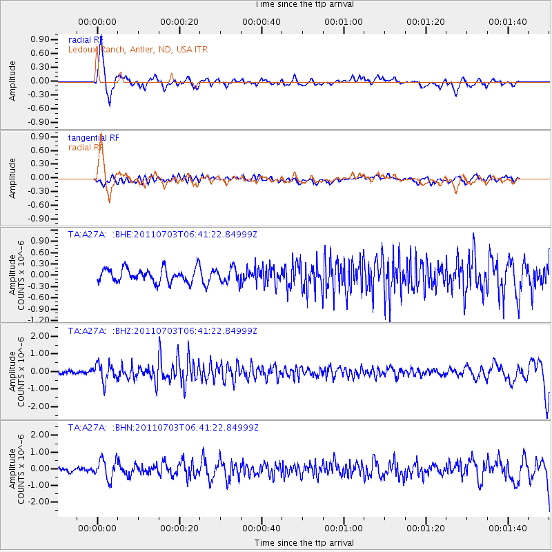
| Radial Match: |
82.10736 % |
| Radial Bump: |
374 |
| Transverse Match: |
56.77309 % |
| Transverse Bump: |
400 |
| SOD ConfigId: |
395004 |
| Insert Time: |
2011-12-10 04:55:50.467 +0000 |
| GWidth: |
2.5 |
| Max Bumps: |
400 |
| Tol: |
0.001 |
|
Signal To Noise
| Channel | StoN | STA | LTA |
| TA:A27A: :BHZ:20110703T06:41:22.84999Z | 5.4483347 | 5.039636E-7 | 9.2498645E-8 |
| TA:A27A: :BHN:20110703T06:41:22.84999Z | 2.7853768 | 5.791102E-7 | 2.079109E-7 |
| TA:A27A: :BHE:20110703T06:41:22.84999Z | 1.0966173 | 1.9651205E-7 | 1.7919837E-7 |
| Arrivals |
| Ps | 5.6 SECOND |
| PpPs | 14 SECOND |
| PsPs/PpSs | 20 SECOND |


