You are here: Home > Network List > TA - USArray Transportable Network (new EarthScope stations) Stations List
> Station L31A Butterfield Farm, Chambers, NE, USA > Earthquake Result Viewer
L31A Butterfield Farm, Chambers, NE, USA - Earthquake Result Viewer
| Earthquake location: |
Near Coast Of Nicaragua |
| Earthquake latitude/longitude: |
12.4/-87.6 |
| Earthquake time(UTC): |
2011/07/03 (184) 06:34:39 GMT |
| Earthquake Depth: |
59 km |
| Earthquake Magnitude: |
5.5 MB, 5.8 MW, 5.7 MW |
| Earthquake Catalog/Contributor: |
WHDF/NEIC |
|
| Network: |
TA USArray Transportable Network (new EarthScope stations) |
| Station: |
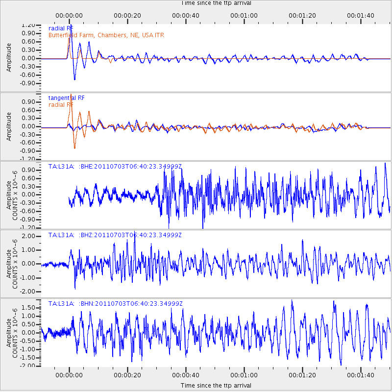
L31A Butterfield Farm, Chambers, NE, USA |
| Lat/Lon: |
42.18 N/98.84 W |
| Elevation: |
670 m |
|
| Distance: |
31.2 deg |
| Az: |
343.753 deg |
| Baz: |
158.426 deg |
| Ray Param: |
0.07903204 |
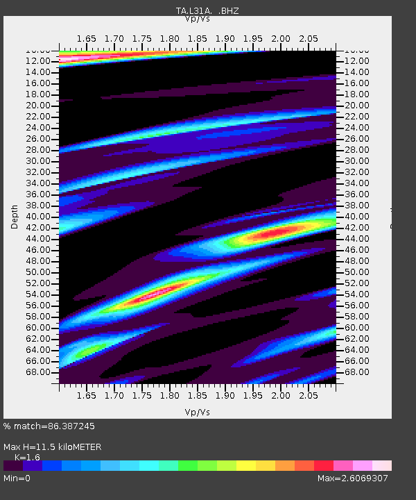
| Estimated Moho Depth: |
11.5 km |
| Estimated Crust Vp/Vs: |
1.60 |
| Assumed Crust Vp: |
6.53 km/s |
| Estimated Crust Vs: |
4.082 km/s |
| Estimated Crust Poisson's Ratio: |
0.18 |
|
| Radial Match: |
86.387245 % |
| Radial Bump: |
389 |
| Transverse Match: |
67.100395 % |
| Transverse Bump: |
400 |
| SOD ConfigId: |
395004 |
| Insert Time: |
2011-12-10 04:56:41.552 +0000 |
| GWidth: |
2.5 |
| Max Bumps: |
400 |
| Tol: |
0.001 |
|
Signal To Noise
| Channel | StoN | STA | LTA |
| TA:L31A: :BHZ:20110703T06:40:23.34999Z | 6.085099 | 5.8164557E-7 | 9.558522E-8 |
| TA:L31A: :BHN:20110703T06:40:23.34999Z | 3.017824 | 5.8172105E-7 | 1.9276177E-7 |
| TA:L31A: :BHE:20110703T06:40:23.34999Z | 2.4975286 | 4.2454442E-7 | 1.6998581E-7 |
| Arrivals |
| Ps | 1.2 SECOND |
| PpPs | 4.2 SECOND |
| PsPs/PpSs | 5.3 SECOND |


