You are here: Home > Network List > TA - USArray Transportable Network (new EarthScope stations) Stations List
> Station G29A Hoven, SD, USA > Earthquake Result Viewer
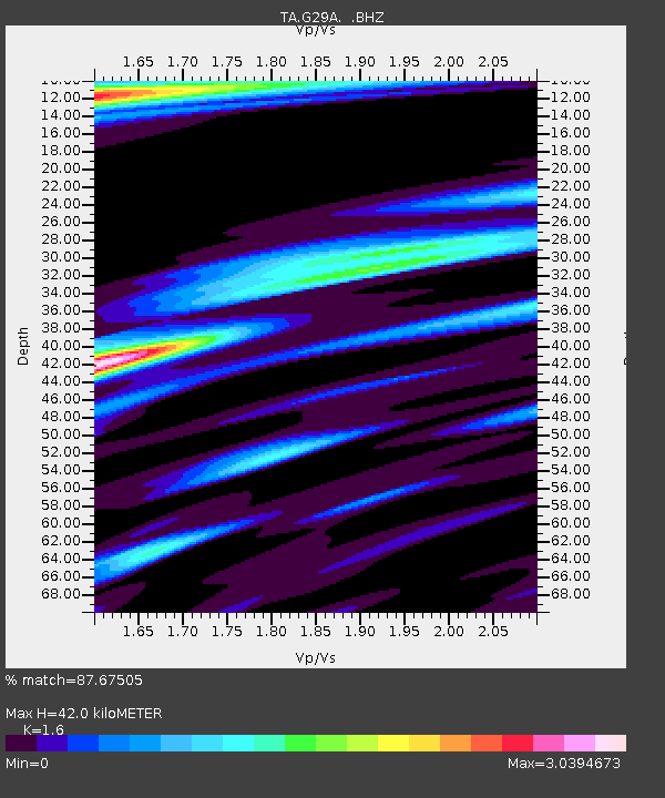
G29A Hoven, SD, USA - Earthquake Result Viewer
| Earthquake location: |
Near Coast Of Nicaragua |
| Earthquake latitude/longitude: |
12.4/-87.6 |
| Earthquake time(UTC): |
2011/07/03 (184) 06:34:39 GMT |
| Earthquake Depth: |
59 km |
| Earthquake Magnitude: |
5.5 MB, 5.8 MW, 5.7 MW |
| Earthquake Catalog/Contributor: |
WHDF/NEIC |
|
| Network: |
TA USArray Transportable Network (new EarthScope stations) |
| Station: |
G29A Hoven, SD, USA |
| Lat/Lon: |
45.19 N/99.92 W |
| Elevation: |
588 m |
|
| Distance: |
34.3 deg |
| Az: |
344.457 deg |
| Baz: |
158.271 deg |
| Ray Param: |
0.07764313 |
| Estimated Moho Depth: |
42.0 km |
| Estimated Crust Vp/Vs: |
1.60 |
| Assumed Crust Vp: |
6.53 km/s |
| Estimated Crust Vs: |
4.082 km/s |
| Estimated Crust Poisson's Ratio: |
0.18 |
|
| Radial Match: |
87.67505 % |
| Radial Bump: |
381 |
| Transverse Match: |
54.252598 % |
| Transverse Bump: |
400 |
| SOD ConfigId: |
395004 |
| Insert Time: |
2011-12-10 04:56:47.832 +0000 |
| GWidth: |
2.5 |
| Max Bumps: |
400 |
| Tol: |
0.001 |
|

Signal To Noise
| Channel | StoN | STA | LTA |
| TA:G29A: :BHZ:20110703T06:40:50.250015Z | 10.349571 | 8.595639E-7 | 8.3053095E-8 |
| TA:G29A: :BHN:20110703T06:40:50.250015Z | 4.203003 | 8.5264827E-7 | 2.0286645E-7 |
| TA:G29A: :BHE:20110703T06:40:50.250015Z | 1.9083189 | 3.4282596E-7 | 1.7964815E-7 |
| Arrivals |
| Ps | 4.2 SECOND |
| PpPs | 15 SECOND |
| PsPs/PpSs | 20 SECOND |


