You are here: Home > Network List > TA - USArray Transportable Network (new EarthScope stations) Stations List
> Station K34A Le Mars, IA, USA > Earthquake Result Viewer
K34A Le Mars, IA, USA - Earthquake Result Viewer
| Earthquake location: |
Near Coast Of Nicaragua |
| Earthquake latitude/longitude: |
12.4/-87.6 |
| Earthquake time(UTC): |
2011/07/03 (184) 06:34:39 GMT |
| Earthquake Depth: |
59 km |
| Earthquake Magnitude: |
5.5 MB, 5.8 MW, 5.7 MW |
| Earthquake Catalog/Contributor: |
WHDF/NEIC |
|
| Network: |
TA USArray Transportable Network (new EarthScope stations) |
| Station: |
K34A Le Mars, IA, USA |
| Lat/Lon: |
42.69 N/96.10 W |
| Elevation: |
436 m |
|
| Distance: |
31.1 deg |
| Az: |
347.787 deg |
| Baz: |
163.723 deg |
| Ray Param: |
0.079087794 |
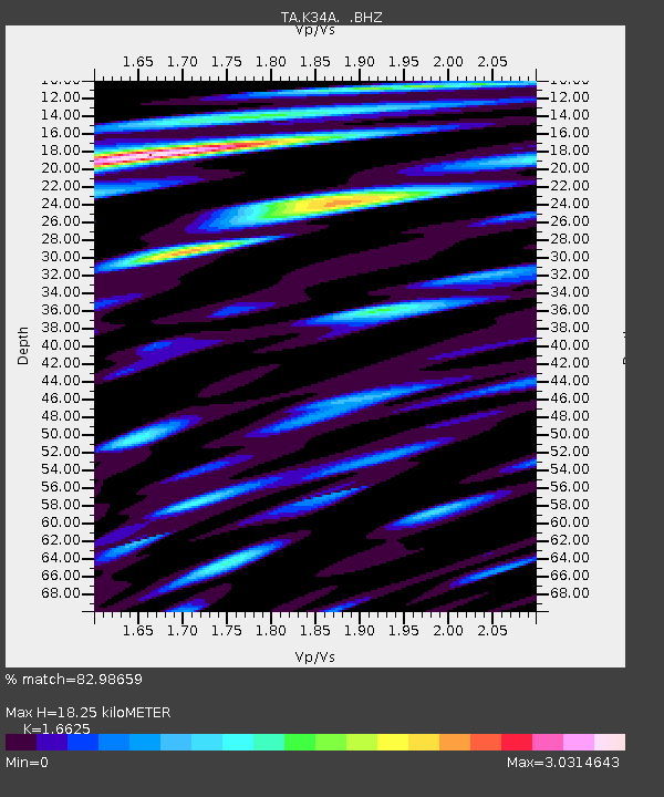
| Estimated Moho Depth: |
18.25 km |
| Estimated Crust Vp/Vs: |
1.66 |
| Assumed Crust Vp: |
6.498 km/s |
| Estimated Crust Vs: |
3.908 km/s |
| Estimated Crust Poisson's Ratio: |
0.22 |
|
| Radial Match: |
82.98659 % |
| Radial Bump: |
400 |
| Transverse Match: |
65.37286 % |
| Transverse Bump: |
400 |
| SOD ConfigId: |
395004 |
| Insert Time: |
2011-12-10 04:58:31.338 +0000 |
| GWidth: |
2.5 |
| Max Bumps: |
400 |
| Tol: |
0.001 |
|
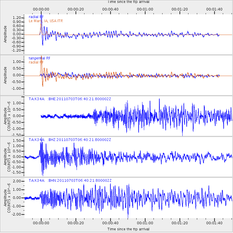
Signal To Noise
| Channel | StoN | STA | LTA |
| TA:K34A: :BHZ:20110703T06:40:21.800002Z | 14.444218 | 7.540442E-7 | 5.220388E-8 |
| TA:K34A: :BHN:20110703T06:40:21.800002Z | 6.291174 | 5.355612E-7 | 8.5128974E-8 |
| TA:K34A: :BHE:20110703T06:40:21.800002Z | 3.6439176 | 2.7155093E-7 | 7.45217E-8 |
| Arrivals |
| Ps | 2.0 SECOND |
| PpPs | 6.9 SECOND |
| PsPs/PpSs | 8.9 SECOND |


