You are here: Home > Network List > TA - USArray Transportable Network (new EarthScope stations) Stations List
> Station J34A George, IA, USA > Earthquake Result Viewer
J34A George, IA, USA - Earthquake Result Viewer
| Earthquake location: |
Near Coast Of Nicaragua |
| Earthquake latitude/longitude: |
12.4/-87.6 |
| Earthquake time(UTC): |
2011/07/03 (184) 06:34:39 GMT |
| Earthquake Depth: |
59 km |
| Earthquake Magnitude: |
5.5 MB, 5.8 MW, 5.7 MW |
| Earthquake Catalog/Contributor: |
WHDF/NEIC |
|
| Network: |
TA USArray Transportable Network (new EarthScope stations) |
| Station: |
J34A George, IA, USA |
| Lat/Lon: |
43.28 N/95.96 W |
| Elevation: |
432 m |
|
| Distance: |
31.6 deg |
| Az: |
348.291 deg |
| Baz: |
164.247 deg |
| Ray Param: |
0.078874975 |
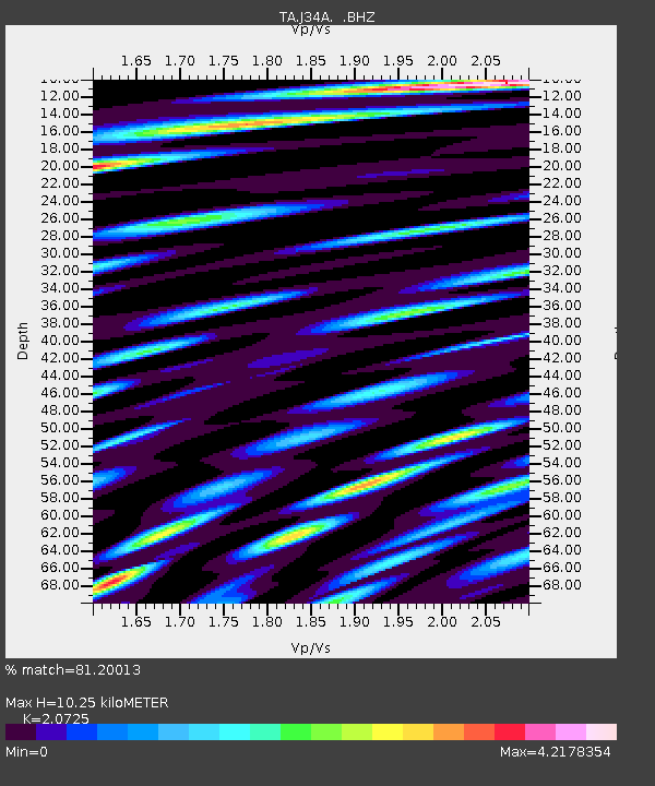
| Estimated Moho Depth: |
10.25 km |
| Estimated Crust Vp/Vs: |
2.07 |
| Assumed Crust Vp: |
6.53 km/s |
| Estimated Crust Vs: |
3.151 km/s |
| Estimated Crust Poisson's Ratio: |
0.35 |
|
| Radial Match: |
81.20013 % |
| Radial Bump: |
400 |
| Transverse Match: |
69.37777 % |
| Transverse Bump: |
400 |
| SOD ConfigId: |
395004 |
| Insert Time: |
2011-12-10 04:58:58.101 +0000 |
| GWidth: |
2.5 |
| Max Bumps: |
400 |
| Tol: |
0.001 |
|

Signal To Noise
| Channel | StoN | STA | LTA |
| TA:J34A: :BHZ:20110703T06:40:26.574996Z | 6.2662244 | 3.966214E-7 | 6.329511E-8 |
| TA:J34A: :BHN:20110703T06:40:26.574996Z | 2.7396874 | 2.8875874E-7 | 1.0539843E-7 |
| TA:J34A: :BHE:20110703T06:40:26.574996Z | 1.4758813 | 1.20577E-7 | 8.16983E-8 |
| Arrivals |
| Ps | 1.8 SECOND |
| PpPs | 4.5 SECOND |
| PsPs/PpSs | 6.3 SECOND |


