You are here: Home > Network List > TA - USArray Transportable Network (new EarthScope stations) Stations List
> Station B31A Greenbush Farm, Park River, ND, USA > Earthquake Result Viewer
B31A Greenbush Farm, Park River, ND, USA - Earthquake Result Viewer
| Earthquake location: |
Near Coast Of Nicaragua |
| Earthquake latitude/longitude: |
12.4/-87.6 |
| Earthquake time(UTC): |
2011/07/03 (184) 06:34:39 GMT |
| Earthquake Depth: |
59 km |
| Earthquake Magnitude: |
5.5 MB, 5.8 MW, 5.7 MW |
| Earthquake Catalog/Contributor: |
WHDF/NEIC |
|
| Network: |
TA USArray Transportable Network (new EarthScope stations) |
| Station: |
B31A Greenbush Farm, Park River, ND, USA |
| Lat/Lon: |
48.42 N/97.65 W |
| Elevation: |
279 m |
|
| Distance: |
36.9 deg |
| Az: |
348.812 deg |
| Baz: |
163.467 deg |
| Ray Param: |
0.076285295 |
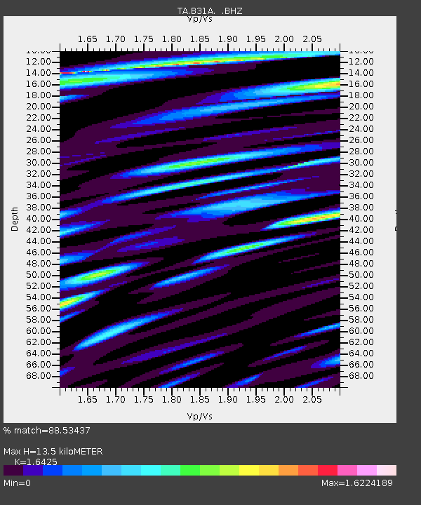
| Estimated Moho Depth: |
13.5 km |
| Estimated Crust Vp/Vs: |
1.64 |
| Assumed Crust Vp: |
6.498 km/s |
| Estimated Crust Vs: |
3.956 km/s |
| Estimated Crust Poisson's Ratio: |
0.21 |
|
| Radial Match: |
88.53437 % |
| Radial Bump: |
400 |
| Transverse Match: |
76.79237 % |
| Transverse Bump: |
400 |
| SOD ConfigId: |
395004 |
| Insert Time: |
2011-12-10 04:59:41.864 +0000 |
| GWidth: |
2.5 |
| Max Bumps: |
400 |
| Tol: |
0.001 |
|

Signal To Noise
| Channel | StoN | STA | LTA |
| TA:B31A: :BHZ:20110703T06:41:12.000015Z | 17.520987 | 9.520496E-7 | 5.4337676E-8 |
| TA:B31A: :BHN:20110703T06:41:12.000015Z | 11.254502 | 9.474597E-7 | 8.418495E-8 |
| TA:B31A: :BHE:20110703T06:41:12.000015Z | 6.1301837 | 3.2543346E-7 | 5.3087064E-8 |
| Arrivals |
| Ps | 1.4 SECOND |
| PpPs | 5.1 SECOND |
| PsPs/PpSs | 6.5 SECOND |


