You are here: Home > Network List > TA - USArray Transportable Network (new EarthScope stations) Stations List
> Station H31A Wolsey, SD, USA > Earthquake Result Viewer
H31A Wolsey, SD, USA - Earthquake Result Viewer
| Earthquake location: |
Near Coast Of Nicaragua |
| Earthquake latitude/longitude: |
12.4/-87.6 |
| Earthquake time(UTC): |
2011/07/03 (184) 06:34:39 GMT |
| Earthquake Depth: |
59 km |
| Earthquake Magnitude: |
5.5 MB, 5.8 MW, 5.7 MW |
| Earthquake Catalog/Contributor: |
WHDF/NEIC |
|
| Network: |
TA USArray Transportable Network (new EarthScope stations) |
| Station: |
H31A Wolsey, SD, USA |
| Lat/Lon: |
44.48 N/98.48 W |
| Elevation: |
415 m |
|
| Distance: |
33.3 deg |
| Az: |
345.734 deg |
| Baz: |
160.348 deg |
| Ray Param: |
0.07813256 |
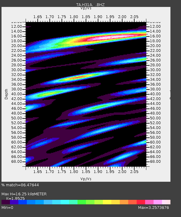
| Estimated Moho Depth: |
16.25 km |
| Estimated Crust Vp/Vs: |
1.95 |
| Assumed Crust Vp: |
6.53 km/s |
| Estimated Crust Vs: |
3.345 km/s |
| Estimated Crust Poisson's Ratio: |
0.32 |
|
| Radial Match: |
86.47644 % |
| Radial Bump: |
384 |
| Transverse Match: |
74.67118 % |
| Transverse Bump: |
400 |
| SOD ConfigId: |
395004 |
| Insert Time: |
2011-12-10 05:00:38.812 +0000 |
| GWidth: |
2.5 |
| Max Bumps: |
400 |
| Tol: |
0.001 |
|
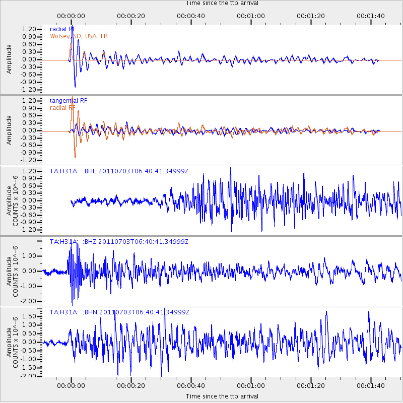
Signal To Noise
| Channel | StoN | STA | LTA |
| TA:H31A: :BHZ:20110703T06:40:41.34999Z | 9.751537 | 9.667486E-7 | 9.913808E-8 |
| TA:H31A: :BHN:20110703T06:40:41.34999Z | 5.9677796 | 4.6372492E-7 | 7.770476E-8 |
| TA:H31A: :BHE:20110703T06:40:41.34999Z | 2.8341877 | 2.3373859E-7 | 8.2471104E-8 |
| Arrivals |
| Ps | 2.5 SECOND |
| PpPs | 6.8 SECOND |
| PsPs/PpSs | 9.4 SECOND |


