You are here: Home > Network List > TA - USArray Transportable Network (new EarthScope stations) Stations List
> Station E35A Pequot Lakes, MN, USA > Earthquake Result Viewer
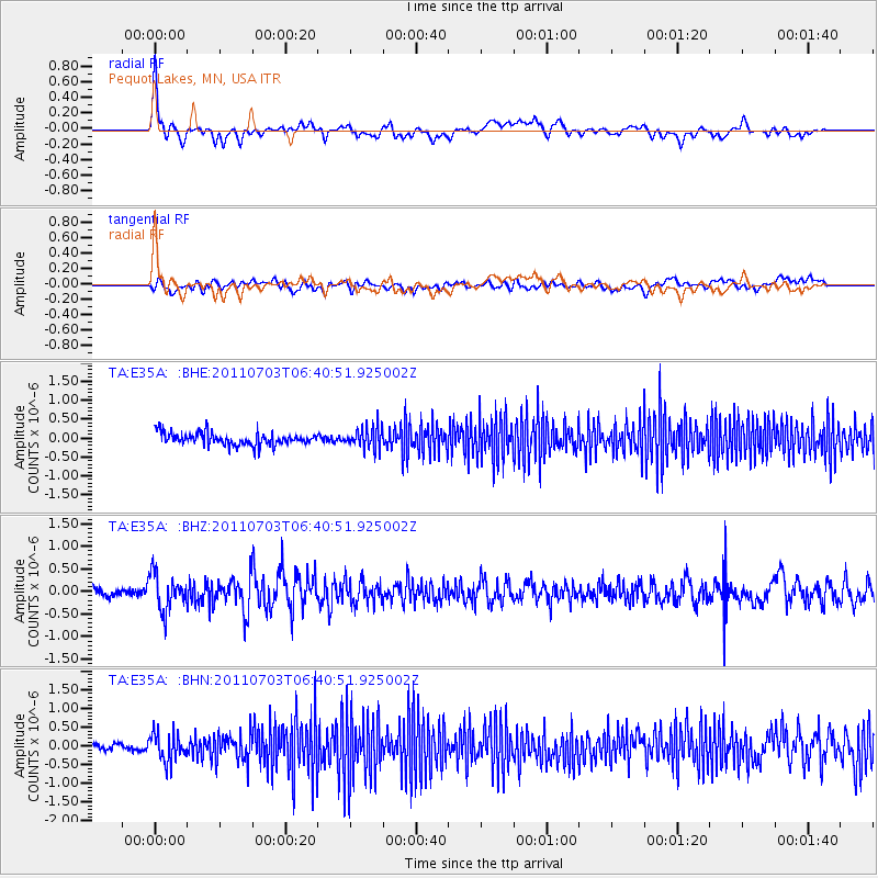
E35A Pequot Lakes, MN, USA - Earthquake Result Viewer
*The percent match for this event was below the threshold and hence no stack was calculated.
| Earthquake location: |
Near Coast Of Nicaragua |
| Earthquake latitude/longitude: |
12.4/-87.6 |
| Earthquake time(UTC): |
2011/07/03 (184) 06:34:39 GMT |
| Earthquake Depth: |
59 km |
| Earthquake Magnitude: |
5.5 MB, 5.8 MW, 5.7 MW |
| Earthquake Catalog/Contributor: |
WHDF/NEIC |
|
| Network: |
TA USArray Transportable Network (new EarthScope stations) |
| Station: |
E35A Pequot Lakes, MN, USA |
| Lat/Lon: |
46.56 N/94.40 W |
| Elevation: |
409 m |
|
| Distance: |
34.5 deg |
| Az: |
351.686 deg |
| Baz: |
168.187 deg |
| Ray Param: |
$rayparam |
*The percent match for this event was below the threshold and hence was not used in the summary stack. |
|
| Radial Match: |
70.51242 % |
| Radial Bump: |
400 |
| Transverse Match: |
48.496346 % |
| Transverse Bump: |
400 |
| SOD ConfigId: |
395004 |
| Insert Time: |
2011-12-10 05:01:04.385 +0000 |
| GWidth: |
2.5 |
| Max Bumps: |
400 |
| Tol: |
0.001 |
|
Signal To Noise
| Channel | StoN | STA | LTA |
| TA:E35A: :BHZ:20110703T06:40:51.925002Z | 1.56425 | 3.986916E-7 | 2.5487716E-7 |
| TA:E35A: :BHN:20110703T06:40:51.925002Z | 1.7915125 | 3.742515E-7 | 2.0890253E-7 |
| TA:E35A: :BHE:20110703T06:40:51.925002Z | 1.7818295 | 2.8554072E-7 | 1.6025143E-7 |
| Arrivals |
| Ps | |
| PpPs | |
| PsPs/PpSs | |


