You are here: Home > Network List > TA - USArray Transportable Network (new EarthScope stations) Stations List
> Station D34A Park Rapids, MN, USA > Earthquake Result Viewer
D34A Park Rapids, MN, USA - Earthquake Result Viewer
| Earthquake location: |
Near Coast Of Nicaragua |
| Earthquake latitude/longitude: |
12.4/-87.6 |
| Earthquake time(UTC): |
2011/07/03 (184) 06:34:39 GMT |
| Earthquake Depth: |
59 km |
| Earthquake Magnitude: |
5.5 MB, 5.8 MW, 5.7 MW |
| Earthquake Catalog/Contributor: |
WHDF/NEIC |
|
| Network: |
TA USArray Transportable Network (new EarthScope stations) |
| Station: |
D34A Park Rapids, MN, USA |
| Lat/Lon: |
47.09 N/95.20 W |
| Elevation: |
476 m |
|
| Distance: |
35.2 deg |
| Az: |
350.956 deg |
| Baz: |
167.013 deg |
| Ray Param: |
0.077216014 |
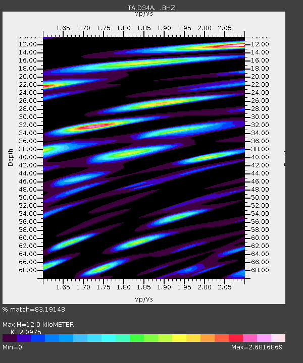
| Estimated Moho Depth: |
12.0 km |
| Estimated Crust Vp/Vs: |
2.10 |
| Assumed Crust Vp: |
6.419 km/s |
| Estimated Crust Vs: |
3.06 km/s |
| Estimated Crust Poisson's Ratio: |
0.35 |
|
| Radial Match: |
83.19148 % |
| Radial Bump: |
400 |
| Transverse Match: |
81.373695 % |
| Transverse Bump: |
400 |
| SOD ConfigId: |
395004 |
| Insert Time: |
2011-12-10 05:01:23.930 +0000 |
| GWidth: |
2.5 |
| Max Bumps: |
400 |
| Tol: |
0.001 |
|

Signal To Noise
| Channel | StoN | STA | LTA |
| TA:D34A: :BHZ:20110703T06:40:57.34999Z | 7.6069098 | 3.2197403E-7 | 4.2326523E-8 |
| TA:D34A: :BHN:20110703T06:40:57.34999Z | 3.10533 | 3.293107E-7 | 1.06046926E-7 |
| TA:D34A: :BHE:20110703T06:40:57.34999Z | 1.1056545 | 1.2813028E-7 | 1.1588636E-7 |
| Arrivals |
| Ps | 2.2 SECOND |
| PpPs | 5.4 SECOND |
| PsPs/PpSs | 7.6 SECOND |


