You are here: Home > Network List > TA - USArray Transportable Network (new EarthScope stations) Stations List
> Station E36A McGregor, MN, USA > Earthquake Result Viewer
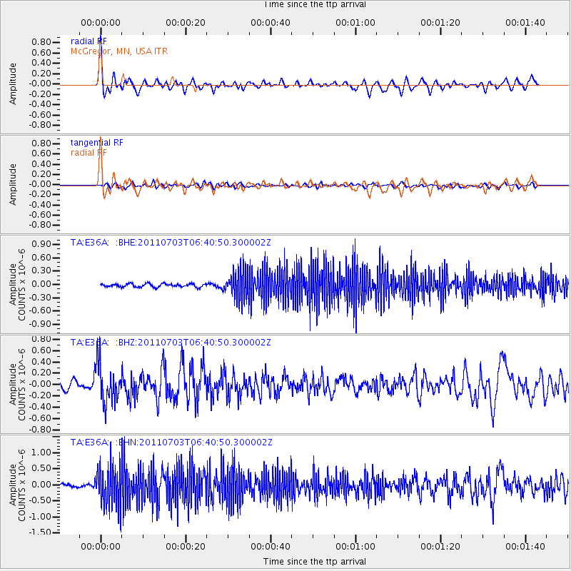
E36A McGregor, MN, USA - Earthquake Result Viewer
*The percent match for this event was below the threshold and hence no stack was calculated.
| Earthquake location: |
Near Coast Of Nicaragua |
| Earthquake latitude/longitude: |
12.4/-87.6 |
| Earthquake time(UTC): |
2011/07/03 (184) 06:34:39 GMT |
| Earthquake Depth: |
59 km |
| Earthquake Magnitude: |
5.5 MB, 5.8 MW, 5.7 MW |
| Earthquake Catalog/Contributor: |
WHDF/NEIC |
|
| Network: |
TA USArray Transportable Network (new EarthScope stations) |
| Station: |
E36A McGregor, MN, USA |
| Lat/Lon: |
46.52 N/93.26 W |
| Elevation: |
393 m |
|
| Distance: |
34.3 deg |
| Az: |
353.05 deg |
| Baz: |
170.143 deg |
| Ray Param: |
$rayparam |
*The percent match for this event was below the threshold and hence was not used in the summary stack. |
|
| Radial Match: |
78.5336 % |
| Radial Bump: |
400 |
| Transverse Match: |
60.65472 % |
| Transverse Bump: |
400 |
| SOD ConfigId: |
395004 |
| Insert Time: |
2011-12-10 05:04:39.617 +0000 |
| GWidth: |
2.5 |
| Max Bumps: |
400 |
| Tol: |
0.001 |
|
Signal To Noise
| Channel | StoN | STA | LTA |
| TA:E36A: :BHZ:20110703T06:40:50.300002Z | 5.997864 | 3.3939182E-7 | 5.6585446E-8 |
| TA:E36A: :BHN:20110703T06:40:50.300002Z | 12.091652 | 6.1700734E-7 | 5.102755E-8 |
| TA:E36A: :BHE:20110703T06:40:50.300002Z | 8.506497 | 3.1499184E-7 | 3.7029558E-8 |
| Arrivals |
| Ps | |
| PpPs | |
| PsPs/PpSs | |


