You are here: Home > Network List > TA - USArray Transportable Network (new EarthScope stations) Stations List
> Station L36A Harm Buss Farm, Glidden, IA, USA > Earthquake Result Viewer
L36A Harm Buss Farm, Glidden, IA, USA - Earthquake Result Viewer
| Earthquake location: |
Near Coast Of Nicaragua |
| Earthquake latitude/longitude: |
12.4/-87.6 |
| Earthquake time(UTC): |
2011/07/03 (184) 06:34:39 GMT |
| Earthquake Depth: |
59 km |
| Earthquake Magnitude: |
5.5 MB, 5.8 MW, 5.7 MW |
| Earthquake Catalog/Contributor: |
WHDF/NEIC |
|
| Network: |
TA USArray Transportable Network (new EarthScope stations) |
| Station: |
L36A Harm Buss Farm, Glidden, IA, USA |
| Lat/Lon: |
42.10 N/94.67 W |
| Elevation: |
353 m |
|
| Distance: |
30.2 deg |
| Az: |
349.494 deg |
| Baz: |
166.151 deg |
| Ray Param: |
0.079308145 |
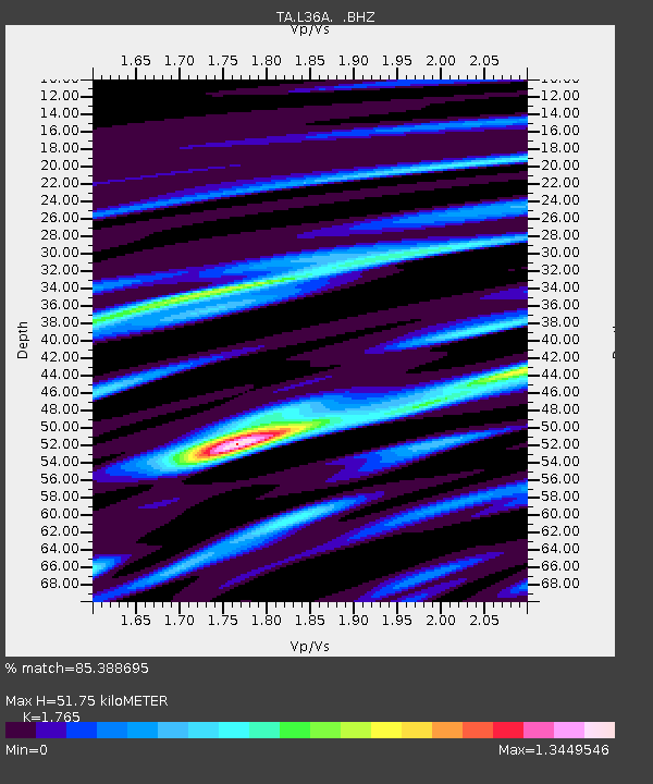
| Estimated Moho Depth: |
51.75 km |
| Estimated Crust Vp/Vs: |
1.76 |
| Assumed Crust Vp: |
6.53 km/s |
| Estimated Crust Vs: |
3.7 km/s |
| Estimated Crust Poisson's Ratio: |
0.26 |
|
| Radial Match: |
85.388695 % |
| Radial Bump: |
400 |
| Transverse Match: |
68.52598 % |
| Transverse Bump: |
400 |
| SOD ConfigId: |
395004 |
| Insert Time: |
2011-12-10 05:05:21.072 +0000 |
| GWidth: |
2.5 |
| Max Bumps: |
400 |
| Tol: |
0.001 |
|

Signal To Noise
| Channel | StoN | STA | LTA |
| TA:L36A: :BHZ:20110703T06:40:14.375015Z | 6.323654 | 4.2272006E-7 | 6.6847434E-8 |
| TA:L36A: :BHN:20110703T06:40:14.375015Z | 7.368668 | 3.878065E-7 | 5.262912E-8 |
| TA:L36A: :BHE:20110703T06:40:14.375015Z | 3.4803731 | 1.984346E-7 | 5.701532E-8 |
| Arrivals |
| Ps | 6.6 SECOND |
| PpPs | 20 SECOND |
| PsPs/PpSs | 27 SECOND |


